Trail Walking Palau-del-Vidre - SAINT ANDRÉ 66 - PALAU-Del-Vidre - TAXO D'AMONT - Photo

SAINT ANDRÉ 66 - PALAU-Del-Vidre - TAXO D'AMONT

 jeff66
jeff66

User

© OpenStreetMap contributors
Length
Length
8.4 km
Max alt
Max alt
34 m
Uphill gradient
Uphill gradient
44 m
Km-Effort
Km-Effort  
9 km
Min alt
Min alt
13 m
Downhill gradient
Downhill gradient
45 m
Boucle
Boucle
Yes
Creation date :
2015-07-02 00:00:00.0
Updated on :
2015-07-02 00:00:00.0

(0 Reviews)

Walking
Walking
1h26
Difficulty : Easy

Scan this QR Code to open this trail in the SityTrail application

FREE GPS app for hiking

Logo SityTrail SityTrail

IGN / Geographical institutes

Download SityTrail from the App Store Download SityTrail from Google Play

Logo SityTrail SityTrail World

The world is yours!

Download SityTrail from the App Store Download SityTrail from Google Play Download SityTrail on Huawei AppGallery

About

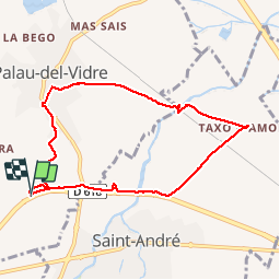
Trail Walking of 8.4 km to be discovered at Occitania, Pyrénées-Orientales, Palau-del-Vidre. This trail is proposed by jeff66.

Description

SAINT ANDRÉ 66 - Matamares - canal de Palau - Agouille Capdal -  PALAU-Del-Vidre - traverse de Saint André - mas Batllo - Agouille Capdal - mas Cassany -  Los Poujols - la joncassa - cours d'eau la Ribereta - passage pont sous la voie ferrée - centre équestre - camp Llarg - vergers de kiwis - TAXO D'AMONT - château - passage voie ferrée - parc photovoltaïque - piste cyclable Argeles St André St Genis le Boulou - passage à gué rivière de St André - Santa Eugenia -

Elevation profile

Photos

Positioning

Country:
France
Region :
Occitania
Department/Province :
Pyrénées-Orientales
Municipality :
Palau-del-Vidre
Location:
Unknown
Start:(Dec)
Start:(UTM)
496487 ; 4711662 (31T) N.

Trails nearby

Trail Walking Laroque-des-Albères - 66 LAROQUE DES ALBERES (maison) SOREDE, par pistes DFCI AL12 et 19, mas del Ca et mas Manere, Itin.16  - Photo
Walking
jeff66

Walking

Medium
(1)
Laroque-des-Albères, Occitania, Pyrénées-Orientales, France
11.2 km | 15.3 km-effort
2h 5min
Yes
Trail Walking Laroque-des-Albères - 66 SOREDE, LAROQUE DES ALBERES, chemins des Mas - Photo
Walking
jeff66

Walking

Medium
(1)
Laroque-des-Albères, Occitania, Pyrénées-Orientales, France
7 km | 8.9 km-effort
1h 22min
Yes
Trail Walking Saint-André - 66 SAINT-ANDRE - SOREDE - chapelle Saint Ferreol de la Pava  - Photo
Walking
jeff66

Walking

Medium
(1)
Saint-André, Occitania, Pyrénées-Orientales, France
14.2 km | 16.9 km-effort
2h 25min
Yes
Trail Walking Palau-del-Vidre - PALAU-DEL-VIDRE 66 - Boucle de Villeclare - promenade dans les vergers et cultures maraîchères  - Photo
Walking
jeff66

Walking

Easy
(2)
Palau-del-Vidre, Occitania, Pyrénées-Orientales, France
7.5 km | 7.9 km-effort
1h 16min
Yes
Trail Walking Laroque-des-Albères - Col-Ullat Pic-aureille_Terrain - Photo
Walking
force

Walking

Medium
(1)
Laroque-des-Albères, Occitania, Pyrénées-Orientales, France
11.2 km | 23 km-effort
4h 47min
Yes
Trail Walking Brouilla - RP66 BROUILLA - BANYULS DELS ASPRES - par les bords de Tech et Vignobles - le 31.03.2017 - Photo
Walking
jeff66

Walking

Easy
(3)
Brouilla, Occitania, Pyrénées-Orientales, France
7.5 km | 8.3 km-effort
1h 26min
Yes
Trail Walking Sorède - RP66 SOREDE - ND du château - la vallée heureuse  - Photo
Walking
jeff66

Walking

Medium
(1)
Sorède, Occitania, Pyrénées-Orientales, France
10.2 km | 14.9 km-effort
1h 48min
Yes
Trail Walking Saint-André - 66 SAINT-ANDRE à PALAU-DEL-VIDRE, canal de Palau, le fort, Villeclare, itinéraire partagé - Photo
Walking
jeff66

Walking

Easy
(1)
Saint-André, Occitania, Pyrénées-Orientales, France
5.7 km | 6.2 km-effort
1h 2min
Yes
Trail Walking Laroque-des-Albères - LAROQUE des A. 66 - Le puits à neige - Casot del Guarda - Photo
Walking
jeff66

Walking

Medium
(2)
Laroque-des-Albères, Occitania, Pyrénées-Orientales, France
12.3 km | 19 km-effort
2h 17min
Yes


Close
My subscriptions