


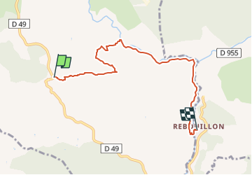
col de la Grange Rebouillon

aljac
User

Length
6.3 km

Max alt
641 m

Uphill gradient
78 m
Km-Effort
8.7 km

Min alt
229 m

Downhill gradient
460 m
Boucle
No
Creation date :
2025-04-27 08:50:37.113
Updated on :
2025-04-27 08:54:21.074
1h58
Difficulty : Medium

FREE GPS app for hiking
 SityTrail
IGN / Geographical institutes
SityTrail Plus
The world is yours!
About
Trail Walking of 6.3 km to be discovered at Provence-Alpes-Côte d'Azur, Var, Ampus. This trail is proposed by aljac.
Description
Quelques difficultés dans la descente du plateau vers la Nartuby d'Ampus, mais le sentier est bien marqué.
Positioning
Country:
France
Region :
Provence-Alpes-Côte d'Azur
Department/Province :
Var
Municipality :
Ampus
Location:
Unknown
Start:(Dec)
Start:(UTM)
289210 ; 4829200 (32T) N.
Comments