


La Vinzelle - 9,9 km - 3h00

Bastet
User
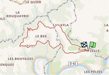

Length
9.8 km

Max alt
582 m

Uphill gradient
279 m
Km-Effort
13.6 km

Min alt
383 m

Downhill gradient
280 m
Boucle
Yes
Creation date :
2018-05-12 00:00:00.0
Updated on :
2022-06-08 17:49:01.149
3h00
Difficulty : Easy

FREE GPS app for hiking
 SityTrail
IGN / Geographical institutes
SityTrail Plus
The world is yours!
About
Trail Walking of 9.8 km to be discovered at Occitania, Aveyron, Conques-en-Rouergue. This trail is proposed by Bastet.
Positioning
Country:
France
Region :
Occitania
Department/Province :
Aveyron
Municipality :
Conques-en-Rouergue
Location:
Grand-Vabre
Start:(Dec)
Start:(UTM)
447983 ; 4943526 (31T) N.
Comments