


Sentier des Glacières + Col des Tempêtes

supercolas
User GUIDE
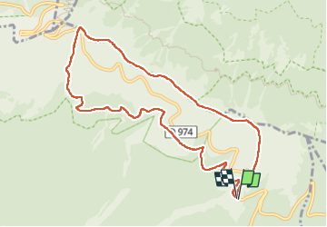

Length
10.3 km

Max alt
1836 m

Uphill gradient
457 m
Km-Effort
16.4 km

Min alt
1445 m

Downhill gradient
455 m
Boucle
Yes
Creation date :
2025-07-26 12:09:29.923
Updated on :
2025-07-27 11:19:20.424
3h02
Difficulty : Difficult

FREE GPS app for hiking
 SityTrail
IGN / Geographical institutes
SityTrail Plus
The world is yours!
About
Trail Walking of 10.3 km to be discovered at Provence-Alpes-Côte d'Azur, Vaucluse, Bédoin. This trail is proposed by supercolas.
Description
ventoux sud
Photos


Positioning
Country:
France
Region :
Provence-Alpes-Côte d'Azur
Department/Province :
Vaucluse
Municipality :
Bédoin
Location:
Unknown
Start:(Dec)
Start:(UTM)
685013 ; 4891257 (31T) N.
Comments