Trail Other activity Gailingen am Hochrhein - bdr12_dSchaffhausen - Photo

Optez pour le retour à la nature GUIDE+

© OpenStreetMap contributors
Length
Length
114 km
Max alt
Max alt
924 m
Uphill gradient
Uphill gradient
3290 m
Km-Effort
Km-Effort  
158 km
Min alt
Min alt
365 m
Downhill gradient
Downhill gradient
3314 m
Boucle
Boucle
No
Creation date :
2016-03-09 00:00:00.0
Updated on :
2016-03-09 00:00:00.0

(0 Reviews)

Other activity
Other activity
35h24
Difficulty : Unknown

Scan this QR Code to open this trail in the SityTrail application

FREE GPS app for hiking

Logo SityTrail SityTrail

IGN / Geographical institutes

Download SityTrail from the App Store Download SityTrail from Google Play

Logo SityTrail SityTrail World

The world is yours!

Download SityTrail from the App Store Download SityTrail from Google Play Download SityTrail on Huawei AppGallery

About

Trail Other activity of 114 km to be discovered at Baden-Württemberg, Landkreis Konstanz, Gailingen am Hochrhein. This trail is proposed by My Switzerland.

Elevation profile

Positioning

Country:
Germany
Region :
Baden-Württemberg
Department/Province :
Landkreis Konstanz
Municipality :
Gailingen am Hochrhein
Location:
Unknown
Start:(UTM)
479571 ; 5282260 (32T) N.

Trails nearby

Trail Cycle Gailingen am Hochrhein - Le lac de Constance de Gailingen à Bodman en passant par Reichenau et Mainau - Photo
Cycle
destras

Cycle

Medium
Gailingen am Hochrhein, Baden-Württemberg, Landkreis Konstanz, Germany
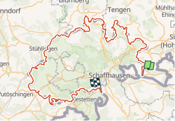
101 km | 116 km-effort
6h 47min
No
Trail Other activity Dörflingen - bdr13_dBusingen - Photo
Other activity
GUIDE+

Other activity

Very easy
Dörflingen, Schaffhausen, Unknown, Switzerland
13.3 km | 16.3 km-effort
3h 48min
No


Close
My subscriptions