Trail Mountain bike Sainte-Ode - Sainte-Ode VTT 42Kms - Photo

Sainte-Ode VTT 42Kms

 B0uille
B0uille

User

© OpenStreetMap contributors
Length
Length
43 km
Max alt
Max alt
566 m
Uphill gradient
Uphill gradient
760 m
Km-Effort
Km-Effort  
53 km
Min alt
Min alt
369 m
Downhill gradient
Downhill gradient
760 m
Boucle
Boucle
Yes
Creation date :
2015-08-21 00:00:00.0
Updated on :
2015-08-21 00:00:00.0

(0 Reviews)

Mountain bike
Mountain bike
3h24
Difficulty : Medium

Scan this QR Code to open this trail in the SityTrail application

FREE GPS app for hiking

Logo SityTrail SityTrail

IGN / Geographical institutes

Download SityTrail from the App Store Download SityTrail from Google Play

Logo SityTrail SityTrail World

The world is yours!

Download SityTrail from the App Store Download SityTrail from Google Play Download SityTrail on Huawei AppGallery

About

Trail Mountain bike of 43 km to be discovered at Wallonia, Luxembourg, Sainte-Ode. This trail is proposed by B0uille.

Elevation profile

Points of interest

Point of interest Sainte-Ode - p01 - Photo
B0uille
SAINTE-ODE 
Point of interest Sainte-Ode - p02 tillet - Photo
B0uille
SAINTE-ODE 
Point of interest Sainte-Ode - p03 Hubermont - Photo
B0uille
SAINTE-ODE 
Point of interest Vaux-sur-Sûre - p04 senonchamps - Photo
B0uille
VAUX-SUR-SÛRE 
Point of interest Vaux-sur-Sûre - p05 poisson moulin - Photo
B0uille
VAUX-SUR-SÛRE 
Point of interest Vaux-sur-Sûre - p06 N848 - Photo
B0uille
VAUX-SUR-SÛRE 
Point of interest Libramont-Chevigny - p07 remagne - Photo
B0uille
LIBRAMONT-CHEVIGNY 
Point of interest Libramont-Chevigny - p08 moircy - Photo
B0uille
LIBRAMONT-CHEVIGNY 
Point of interest Libramont-Chevigny - p09 bonneru - Photo
B0uille
LIBRAMONT-CHEVIGNY 
Point of interest Sainte-Ode - p10 amberloup - Photo
B0uille
SAINTE-ODE 
Point of interest Sainte-Ode - Start ste ode - Photo
B0uille
SAINTE-ODE 

Positioning

Country:
Belgium
Region :
Wallonia
Department/Province :
Luxembourg
Municipality :
Sainte-Ode
Location:
Amberloup
Start:(UTM)
682492 ; 5545838 (31U) N.

Trails nearby

Trail Walking Sainte-Ode - RB-LUX-08 - Raccourci - De part et d’autre de l’Ourthe occidentale - Photo
Walking
PRO

Walking

Difficult
(2)
Sainte-Ode, Wallonia, Luxembourg, Belgium
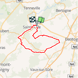
15.2 km | 18.6 km-effort
4h 13min
Yes
Trail Walking Sainte-Ode - Tonny - Promenade de Tonny (A6) - Photo
Walking
GUIDE+

Walking

Medium
(3)
Sainte-Ode, Wallonia, Luxembourg, Belgium
9.5 km | 12.2 km-effort
2h 36min
Yes
Trail Walking Sainte-Ode - Beauplateau - Promenade du Pleurotte (T7) - Photo
Walking
GUIDE+

Walking

Medium
(2)
Sainte-Ode, Wallonia, Luxembourg, Belgium
5.5 km | 6.9 km-effort
1h 29min
Yes
Trail Walking Sainte-Ode - Lavacherie - Promenade de la Bonne Dame (L1) - Photo
Walking
GUIDE+

Walking

Medium
(4)
Sainte-Ode, Wallonia, Luxembourg, Belgium
7.7 km | 10 km-effort
2h 10min
Yes
Trail Walking Sainte-Ode - Amberloup, Natura 2000 - Des sites qui valent le détour. Lx11 - Photo
Walking
GUIDE+

Walking

Easy
(4)
Sainte-Ode, Wallonia, Luxembourg, Belgium
4.2 km | 5 km-effort
1h 6min
Yes
Trail Walking Sainte-Ode - RB-LUX-08 - De part et d’autre de l’Ourthe occidentale - Photo
Walking
PRO

Walking

Medium
(1)
Sainte-Ode, Wallonia, Luxembourg, Belgium
23 km | 29 km-effort
6h 14min
Yes
Trail On foot Sainte-Ode - Dans Freyr par Bokaissart - Photo
On foot
lancelot.be

On foot

Medium
(1)
Sainte-Ode, Wallonia, Luxembourg, Belgium
4.6 km | 5.9 km-effort
1h 25min
Yes
Trail Walking Sainte-Ode - Beauplateau - Le sentier du Coprin (GTA 4) - Photo
Walking
GUIDE+

Walking

Very difficult
(2)
Sainte-Ode, Wallonia, Luxembourg, Belgium
16.6 km | 20 km-effort
4h 20min
Yes
Trail Walking Sainte-Ode - Tonny - Promenade de bois Cousin (A7) - Photo
Walking
GUIDE+

Walking

Medium
(2)
Sainte-Ode, Wallonia, Luxembourg, Belgium
5.8 km | 7.9 km-effort
1h 40min
Yes


Close
My subscriptions