Trail Walking Saint-Cergue - YHH082 La Cure - St Cergue - Photo

YHH082 La Cure - St Cergue

© OpenStreetMap contributors
Length
Length
12.8 km
Max alt
Max alt
1466 m
Uphill gradient
Uphill gradient
415 m
Km-Effort
Km-Effort  
18.7 km
Min alt
Min alt
1046 m
Downhill gradient
Downhill gradient
525 m
Boucle
Boucle
No
Creation date :
2014-12-10 00:00:00.0
Updated on :
2014-12-10 00:00:00.0

(0 Reviews)

Walking
Walking
4h00
Difficulty : Unknown

Scan this QR Code to open this trail in the SityTrail application

FREE GPS app for hiking

Logo SityTrail SityTrail

IGN / Geographical institutes

Download SityTrail from the App Store Download SityTrail from Google Play

Logo SityTrail SityTrail World

The world is yours!

Download SityTrail from the App Store Download SityTrail from Google Play Download SityTrail on Huawei AppGallery

About

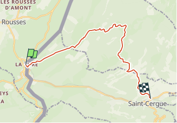
Trail Walking of 12.8 km to be discovered at Vaud, District de Nyon, Saint-Cergue. This trail is proposed by yveshumbert.

Description

Parquer se voiture à St-Cergue dans le parking de l''office du tourisme. Marcher les 5 minutes pour aller à la gare. Prendre le train pour aller à la Cure.  On revient à St-Cergue par de jolis petit chemins.

Elevation profile

Points of interest

Point of interest Saint-Cergue - Gare - Photo
yveshumbert
SAINT-CERGUE 
Point of interest Saint-Cergue - Gare - Photo
yveshumbert
SAINT-CERGUE 

Positioning

Country:
Switzerland
Region :
Vaud
Department/Province :
District de Nyon
Municipality :
Saint-Cergue
Location:
Unknown
Start:(UTM)
275256 ; 5149870 (32T) N.

Trails nearby

Trail Cycle  - Lac de Lamoura et Valserine - Prémanon - Photo
Cycle
tracegps

Cycle

Medium
(1)
, Bourgogne-Franche-Comté, Jura, France
39 km | 49 km-effort
2h 0min
Yes
Trail Walking  - Le Belvédère des Maquisards - Prémanon - Photo
Walking
tracegps

Walking

Medium
(1)
, Bourgogne-Franche-Comté, Jura, France
5.4 km | 7.8 km-effort
2h 0min
Yes
Trail Walking  - Autour de Prémanon - Photo
Walking
tracegps

Walking

Very difficult
(1)
, Bourgogne-Franche-Comté, Jura, France
18 km | 27 km-effort
6h 0min
Yes
Trail Walking Les Rousses - Le Noirmont - Les Rousses - Photo
Walking
tracegps

Walking

Very difficult
(2)
Les Rousses, Bourgogne-Franche-Comté, Jura, France
15.1 km | 23 km-effort
6h 0min
Yes
Trail Walking Prémanon - dole1 - Photo
Walking
fredj

Walking

Very easy
(2)
Prémanon, Bourgogne-Franche-Comté, Jura, France
6.6 km | 12.5 km-effort
1h 49min
Yes
Trail On foot  - Les Arcets - Photo
On foot
PRO

On foot

Easy
, Bourgogne-Franche-Comté, Jura, France
9 km | 13.6 km-effort
3h 5min
Yes
Trail On foot Gingins - La Dôle - Photo
On foot
PRO

On foot

Easy
Gingins, Vaud, District de Nyon, Switzerland
8 km | 15.4 km-effort
3h 30min
Yes
Trail Walking  - Prémanon, Mont Fier  - Photo
Walking
MoiClaude

Walking

Very easy
(1)
, Bourgogne-Franche-Comté, Jura, France
10.9 km | 15.8 km-effort
2h 34min
No
Trail Snowshoes Les Rousses - Lac des Rousses  - Photo
Snowshoes
nfranche

Snowshoes

Medium
(1)
Les Rousses, Bourgogne-Franche-Comté, Jura, France
13.8 km | 18.4 km-effort
4h 15min
Yes


Close
My subscriptions