Trail Walking Beauchemin - beauchemin. haute marne - Photo

beauchemin. haute marne

 gimbretb
gimbretb

User

© OpenStreetMap contributors
Length
Length
15.3 km
Max alt
Max alt
421 m
Uphill gradient
Uphill gradient
196 m
Km-Effort
Km-Effort  
17.9 km
Min alt
Min alt
334 m
Downhill gradient
Downhill gradient
192 m
Boucle
Boucle
Yes
Creation date :
2015-10-15 00:00:00.0
Updated on :
2015-10-15 00:00:00.0

(0 Reviews)

Walking
Walking
3h32
Difficulty : Unknown

Scan this QR Code to open this trail in the SityTrail application

FREE GPS app for hiking

Logo SityTrail SityTrail

IGN / Geographical institutes

Download SityTrail from the App Store Download SityTrail from Google Play

Logo SityTrail SityTrail World

The world is yours!

Download SityTrail from the App Store Download SityTrail from Google Play Download SityTrail on Huawei AppGallery

About

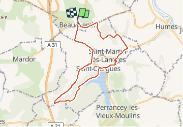
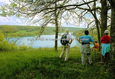
Trail Walking of 15.3 km to be discovered at Grand Est, Haute-Marne, Beauchemin. This trail is proposed by gimbretb.

Description

facile. parking à l'église.

Elevation profile

Positioning

Country:
France
Region :
Grand Est
Department/Province :
Haute-Marne
Municipality :
Beauchemin
Location:
Unknown
Start:(UTM)
667463 ; 5308053 (31T) N.

Trails nearby

Trail Walking Saint-Ciergues - Tour du lac de la mouche - Photo
Walking
Tomtom88210

Walking

Medium
Saint-Ciergues, Grand Est, Haute-Marne, France
7.5 km | 8.5 km-effort
1h 59min
Yes
Trail Walking Marac - marac et la suize - Photo
Walking
Nicole SIMONNET

Walking

Medium
Marac, Grand Est, Haute-Marne, France
9.2 km | 10.5 km-effort
2h 42min
Yes
Trail Mountain bike Faverolles - La Via Francigena - Traversée de la Haute Marne -de Faverolles à Langres - Photo
Mountain bike
tracegps

Mountain bike

Medium
Faverolles, Grand Est, Haute-Marne, France
24 km | 29 km-effort
2h 15min
No
Trail Walking Faverolles - La Via Francigena - Traversée de la Haute Marne -de Faverolles à Langres - Photo
Walking
tracegps

Walking

Medium
Faverolles, Grand Est, Haute-Marne, France
24 km | 29 km-effort
5h 0min
No
Trail Mountain bike Saint-Ciergues - Tour du lac de la Mouche -Saint Ciergues, Perrancey Les Vieux Moulins - Photo
Mountain bike
tracegps

Mountain bike

Medium
Saint-Ciergues, Grand Est, Haute-Marne, France
7 km | 8 km-effort
34min
Yes
Trail Walking Saint-Ciergues - Tour du lac de la Mouche -Saint Ciergues, Perrancey Les Vieux Moulins - Photo
Walking
tracegps

Walking

Medium
Saint-Ciergues, Grand Est, Haute-Marne, France
7 km | 8 km-effort
1h 30min
Yes
Trail Mountain bike Saint-Ciergues - Les Roches - Saint Ciergues - Photo
Mountain bike
tracegps

Mountain bike

Easy
Saint-Ciergues, Grand Est, Haute-Marne, France
3.1 km | 3.9 km-effort
19min
Yes
Trail Walking Saint-Ciergues - Les Roches - Saint Ciergues - Photo
Walking
tracegps

Walking

Easy
Saint-Ciergues, Grand Est, Haute-Marne, France
3.1 km | 3.9 km-effort
1h 0min
Yes
Trail Mountain bike Humes-Jorquenay - Le Val de Mouche - Humes - Photo
Mountain bike
tracegps

Mountain bike

Very difficult
Humes-Jorquenay, Grand Est, Haute-Marne, France
18.7 km | 23 km-effort
2h 30min
Yes


Close
My subscriptions