Trail Walking Toulouges - 66 TOULOUGES - CANOHES piste cyclable itinéraire partagé et canal - Photo

66 TOULOUGES - CANOHES piste cyclable itinéraire partagé et canal

 jeff66
jeff66

User

© OpenStreetMap contributors
Length
Length
8 km
Max alt
Max alt
68 m
Uphill gradient
Uphill gradient
44 m
Km-Effort
Km-Effort  
8.6 km
Min alt
Min alt
50 m
Downhill gradient
Downhill gradient
44 m
Boucle
Boucle
Yes
Creation date :
2015-10-21 00:00:00.0
Updated on :
2015-10-21 00:00:00.0

(0 Reviews)

Walking
Walking
1h15
Difficulty : Easy

Scan this QR Code to open this trail in the SityTrail application

FREE GPS app for hiking

Logo SityTrail SityTrail

IGN / Geographical institutes

Download SityTrail from the App Store Download SityTrail from Google Play

Logo SityTrail SityTrail World

The world is yours!

Download SityTrail from the App Store Download SityTrail from Google Play Download SityTrail on Huawei AppGallery

About

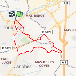
Trail Walking of 8 km to be discovered at Occitania, Pyrénées-Orientales, Toulouges. This trail is proposed by jeff66.

Description

66 TOULOUGES - CANOHES piste cyclable itinéraire partagé, Naturopole, passage sous la RD612a, rond point de la Sanya - CANOHES, av. des Massaguères, complexe  sportif ASPTT, canal de Perpignan, La Solane, mas Gaffard, les carlettes - les Pavillons - mas coma Serra - mas Aulas - TOULOUGES,longer la RD612a, et les Passeres Roges, Intermarché. Clairfont - collège F. Mitterand, allée de Tarragone,  rue de Gerone, ch. de las palan as. Rue Fr. Garcia Lorca, chemin des Roures

Elevation profile

Photos

Positioning

Country:
France
Region :
Occitania
Department/Province :
Pyrénées-Orientales
Municipality :
Toulouges
Location:
Unknown
Start:(UTM)
486345 ; 4724481 (31T) N.

Trails nearby

Trail Walking Perpignan - Perpignan 01.10.2017  - Photo
Walking
jeff66

Walking

Easy
(1)
Perpignan, Occitania, Pyrénées-Orientales, France
6.7 km | 7.5 km-effort
1h 39min
No
Trail Mountain bike Canohès - canohes - Photo
Mountain bike
haroldtheviking

Mountain bike

Medium
(2)
Canohès, Occitania, Pyrénées-Orientales, France
37 km | 44 km-effort
2h 12min
Yes
Trail Walking Perpignan - canal Perpignan  - Photo
Walking
Fildesir

Walking

Very easy
Perpignan, Occitania, Pyrénées-Orientales, France
25 km | 27 km-effort
7h 29min
No
Trail Walking Perpignan - 66 Perpignan Panchot centre bas Vernet centre del mon - Photo
Walking
jeff66

Walking

Easy
Perpignan, Occitania, Pyrénées-Orientales, France
8.6 km | 9.3 km-effort
1h 29min
Yes
Trail Walking Perpignan - 66 PERPIGNAN - autour des mas Du petit et du grand Bresson - Photo
Walking
jeff66

Walking

Easy
Perpignan, Occitania, Pyrénées-Orientales, France
4.3 km | 4.9 km-effort
52min
Yes
Trail Walking Perpignan - 66 PERPIGNAN, du sud au Nord Et retour - Photo
Walking
jeff66

Walking

Medium
Perpignan, Occitania, Pyrénées-Orientales, France
13.8 km | 15.4 km-effort
2h 40min
Yes
Trail Walking Perpignan - 66 PERPIGNAN - CANOHES par le canal et le ch. des Carlettes - Photo
Walking
jeff66

Walking

Medium
(1)
Perpignan, Occitania, Pyrénées-Orientales, France
9.4 km | 10.1 km-effort
1h 45min
Yes
Trail Walking Perpignan - 66 PERPIGNAN porte Espagne, les arcades, saint Martin, moulin à vent, vertefeuille, mas Gaffard - Photo
Walking
jeff66

Walking

Medium
Perpignan, Occitania, Pyrénées-Orientales, France
10.3 km | 11.7 km-effort
1h 48min
Yes
Trail Walking Baho - 66 SAINT-ESTEVE, promenade entre jardins, canaux et centre ville - Photo
Walking
jeff66

Walking

Easy
Baho, Occitania, Pyrénées-Orientales, France
6.9 km | 7.3 km-effort
1h 16min
Yes


Close
My subscriptions