Trail Other activity Chevannes - M3 - Photo
© OpenStreetMap contributors
Length
Length
12.5 km
Max alt
Max alt
121 m
Uphill gradient
Uphill gradient
129 m
Km-Effort
Km-Effort  
14.2 km
Min alt
Min alt
90 m
Downhill gradient
Downhill gradient
129 m
Boucle
Boucle
Yes
Creation date :
2015-10-25 00:00:00.0
Updated on :
2015-10-25 00:00:00.0

(0 Reviews)

Other activity
Other activity
--
Difficulty : Unknown

Scan this QR Code to open this trail in the SityTrail application

FREE GPS app for hiking

Logo SityTrail SityTrail

IGN / Geographical institutes

Download SityTrail from the App Store Download SityTrail from Google Play

Logo SityTrail SityTrail World

The world is yours!

Download SityTrail from the App Store Download SityTrail from Google Play Download SityTrail on Huawei AppGallery

About

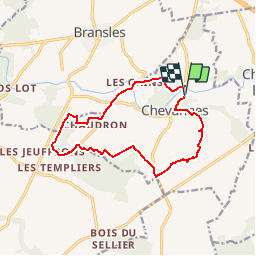
Trail Other activity of 12.5 km to be discovered at Centre-Loire Valley, Loiret, Chevannes. This trail is proposed by brunoperrier.

Description

NOM_BOUCLE = M3<br />NOM_LONG = PR des Deux Rivières<br />

Elevation profile

Points of interest

Point of interest Chevannes - M3 - Photo
brunoperrier
CHEVANNES 

Positioning

Country:
France
Region :
Centre-Loire Valley
Department/Province :
Loiret
Municipality :
Chevannes
Location:
Unknown
Start:(UTM)
489870 ; 5331685 (31U) N.

Trails nearby

Trail On foot Le Bignon-Mirabeau - PR de César - Photo
On foot
PRO

On foot

Easy
Le Bignon-Mirabeau, Centre-Loire Valley, Loiret, France
3.1 km | 3.4 km-effort
45min
No
Trail Walking Égreville - egrevilleSR061019 - Photo
Walking
fmg

Walking

Easy
Égreville, Ile-de-France, Seine-et-Marne, France
20 km | 22 km-effort
4h 33min
Yes
Trail Walking Le Bignon-Mirabeau - GJ janvier 2013 - Photo
Walking
mdeclemy

Walking

Medium
Le Bignon-Mirabeau, Centre-Loire Valley, Loiret, France
24 km | 27 km-effort
5h 49min
Yes
Trail On foot Chaintreaux - Forêt de Cercanceaux - Photo
On foot
alainchachignon

On foot

Easy
Chaintreaux, Ile-de-France, Seine-et-Marne, France
8.9 km | 10.3 km-effort
2h 20min
Yes
Trail Walking Égreville - autour Degreville  - Photo
Walking
Jean Marc Gibout

Walking

Very difficult
Égreville, Ile-de-France, Seine-et-Marne, France
19 km | 21 km-effort
4h 20min
No
Trail On foot Bransles - Bransles les moulins du Betz - Photo
On foot
alainchachignon

On foot

Easy
Bransles, Ile-de-France, Seine-et-Marne, France
8.2 km | 9.3 km-effort
2h 6min
Yes
Trail Walking Bransles - BG2018 - Photo
Walking
micheljannot

Walking

Easy
Bransles, Ile-de-France, Seine-et-Marne, France
14.2 km | 16.6 km-effort
3h 37min
Yes
Trail Walking Bransles - Ardouzes et Betz - Photo
Walking
micheljannot

Walking

Easy
Bransles, Ile-de-France, Seine-et-Marne, France
13.9 km | 16.1 km-effort
3h 33min
Yes
Trail Walking Le Bignon-Mirabeau - Bignon Mir essai - Photo
Walking
kayakC

Walking

Very easy
Le Bignon-Mirabeau, Centre-Loire Valley, Loiret, France
23 km | 26 km-effort
Unknown
Yes


Close
My subscriptions