Trail Walking Anniviers - Saint-Luc, Lacs d''Armina et Combavert - Photo

Saint-Luc, Lacs d''Armina et Combavert

 rpf
rpf

User

© OpenStreetMap contributors
Length
Length
10.5 km
Max alt
Max alt
2616 m
Uphill gradient
Uphill gradient
481 m
Km-Effort
Km-Effort  
18.5 km
Min alt
Min alt
1682 m
Downhill gradient
Downhill gradient
960 m
Boucle
Boucle
No
Creation date :
2014-12-10 00:00:00.0
Updated on :
2014-12-10 00:00:00.0

(0 Reviews)

Walking
Walking
5h30
Difficulty : Unknown

Scan this QR Code to open this trail in the SityTrail application

FREE GPS app for hiking

Logo SityTrail SityTrail

IGN / Geographical institutes

Download SityTrail from the App Store Download SityTrail from Google Play

Logo SityTrail SityTrail World

The world is yours!

Download SityTrail from the App Store Download SityTrail from Google Play Download SityTrail on Huawei AppGallery

About

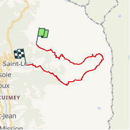
Trail Walking of 10.5 km to be discovered at Valais/Wallis, Sierre, Anniviers. This trail is proposed by rpf.

Description

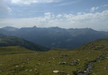
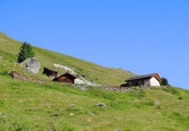
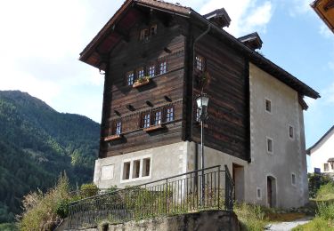
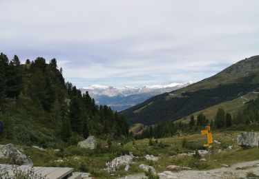
Par le funiculaire rapide de Tignousa, l''observatoire François-Xavier Bagnoud et le chemin des Planètes, une montée en pente douce vers le Meidpass et  les lacs de Saint-Luc. Retour sous le Touno et le long de l''impétueux Torrent des Moulins. Une longue promenade pleine de richesse et de diversité...

Une balade de  " www.toprando.ch "

Elevation profile

Positioning

Country:
Switzerland
Region :
Valais/Wallis
Department/Province :
Sierre
Municipality :
Anniviers
Location:
Unknown
Start:(UTM)
392795 ; 5120463 (32T) N.

Trails nearby

Trail Walking Anniviers - St Luc Bella Tolla lacs - circuit - Photo
Walking
elcanario

Walking

Easy
(1)
Anniviers, Valais/Wallis, Sierre, Switzerland
11.5 km | 19.5 km-effort
3h 45min
No
Trail On foot Anniviers - Chandolin-St Luc - Photo
On foot
PRO

On foot

Easy
Anniviers, Valais/Wallis, Sierre, Switzerland
4.9 km | 7.4 km-effort
1h 40min
No
Trail On foot Anniviers - Hôtel Weisshorn-Zinal - Photo
On foot
PRO

On foot

Easy
Anniviers, Valais/Wallis, Sierre, Switzerland
11.3 km | 15.5 km-effort
3h 31min
No
Trail On foot Anniviers - Grand Bisse de St-Jean - Photo
On foot
PRO

On foot

Easy
Anniviers, Valais/Wallis, Sierre, Switzerland
5 km | 8.4 km-effort
1h 54min
No
Trail Walking Anniviers - weisshorn - Photo
Walking
suzanne.bron

Walking

Medium
Anniviers, Valais/Wallis, Sierre, Switzerland
4.7 km | 7.4 km-effort
1h 43min
No
Trail Nordic walking Anniviers - Weisshorn - Photo
Nordic walking
suzanne.bron

Nordic walking

Very easy
Anniviers, Valais/Wallis, Sierre, Switzerland
14.2 km | 21 km-effort
4h 36min
No
Trail On foot Anniviers - Tignousa-Le Tsapé - Photo
On foot
PRO

On foot

Easy
Anniviers, Valais/Wallis, Sierre, Switzerland
3.8 km | 7.7 km-effort
1h 45min
No
Trail On foot Oberems - Meidpass-Toûno - Photo
On foot
PRO

On foot

Easy
Oberems, Valais/Wallis, Leuk, Switzerland
3.5 km | 5.4 km-effort
1h 13min
No
Trail Other activity Anniviers - st_bg_ponchet - Photo
Other activity
GUIDE+

Other activity

Very easy
Anniviers, Valais/Wallis, Sierre, Switzerland
8.8 km | 15.9 km-effort
2h 51min
No


Close
My subscriptions