Trail Walking Ardon - Ardon, Gorges de la Lizerne - Photo

Ardon, Gorges de la Lizerne

 rpf
rpf

User

© OpenStreetMap contributors
Length
Length
9.8 km
Max alt
Max alt
1378 m
Uphill gradient
Uphill gradient
533 m
Km-Effort
Km-Effort  
16.9 km
Min alt
Min alt
1028 m
Downhill gradient
Downhill gradient
533 m
Boucle
Boucle
Yes
Creation date :
2014-12-10 00:00:00.0
Updated on :
2014-12-10 00:00:00.0

(0 Reviews)

Walking
Walking
4h30
Difficulty : Unknown

Scan this QR Code to open this trail in the SityTrail application

FREE GPS app for hiking

Logo SityTrail SityTrail

IGN / Geographical institutes

Download SityTrail from the App Store Download SityTrail from Google Play

Logo SityTrail SityTrail World

The world is yours!

Download SityTrail from the App Store Download SityTrail from Google Play Download SityTrail on Huawei AppGallery

About

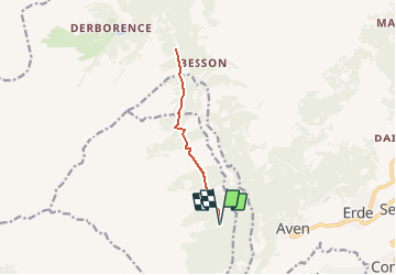
Trail Walking of 9.8 km to be discovered at Valais/Wallis, Conthey, Ardon. This trail is proposed by rpf.

Description

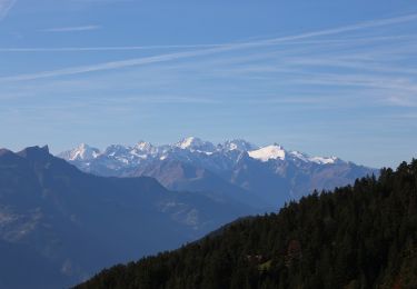
Sur les flancs de Haut-de-Cry, des hauts d''Ardon jusqu''à Derborence. Une vallée restée très fermée sous des parois rocheuses impressionnantes...

Départ au-dessus d''Ardon, sur la route forestière qui surplombe les Gorges de la Lizerne.
On peut y choisir le point de départ en fonction de l''aptitude à conduire et de la sensibilité aux vertiges!... mais un passage est très déconseillé juste avant Grand Dzeu.
Retour par le même chemin.

NB Le calcul du dénivelé a été exagéré (!)

Une balade de  " www.toprando.ch "

Elevation profile

Positioning

Country:
Switzerland
Region :
Valais/Wallis
Department/Province :
Conthey
Municipality :
Ardon
Location:
Unknown
Start:(UTM)
364957 ; 5121873 (32T) N.

Trails nearby

Trail On foot Ardon - Chemin des berges du Rhône - Photo
On foot
PRO

On foot

Easy
Ardon, Valais/Wallis, Conthey, Switzerland
4.4 km | 4.9 km-effort
1h 6min
No
Trail On foot Conthey - Bisse de la Tsandra - Photo
On foot
PRO

On foot

Easy
Conthey, Valais/Wallis, Conthey, Switzerland
7.4 km | 10.5 km-effort
2h 23min
No
Trail Other activity Conthey - st_bg_conthey - Photo
Other activity
GUIDE+

Other activity

Very easy
Conthey, Valais/Wallis, Conthey, Switzerland
22 km | 42 km-effort
9h 21min
No
Trail Walking Conthey - huetten_02 - Photo
Walking
GUIDE+

Walking

Very easy
Conthey, Valais/Wallis, Conthey, Switzerland
50 km | 102 km-effort
16h 52min
Yes
Trail Walking Conthey - Lac Forcla - Photo
Walking
jipi2

Walking

Medium
Conthey, Valais/Wallis, Conthey, Switzerland
16.8 km | 33 km-effort
8h 1min
Yes
Trail Walking Conthey - Martigny-Kandersteg (3) Hotel du Sanetsch - Photo
Walking
rpf

Walking

Very easy
Conthey, Valais/Wallis, Conthey, Switzerland
14.8 km | 28 km-effort
6h 45min
No
Trail Walking Ardon - Ardon, Einzon - Photo
Walking
rpf

Walking

Very easy
Ardon, Valais/Wallis, Conthey, Switzerland
8.1 km | 21 km-effort
6h 30min
Yes
Trail Walking Conthey - Derborence, Pas de Cheville - Photo
Walking
rpf

Walking

Very easy
Conthey, Valais/Wallis, Conthey, Switzerland
8.8 km | 18.1 km-effort
5h 30min
Yes
Trail Walking Conthey - Tour des Muverans - Photo
Walking
rpf

Walking

Very easy
Conthey, Valais/Wallis, Conthey, Switzerland
48 km | 101 km-effort
23h 45min
Yes


Close
My subscriptions