Trail Walking Lavey-Morcles - Morcles, Pointe des Martinets - Photo

Morcles, Pointe des Martinets

 rpf
rpf

User

© OpenStreetMap contributors
Length
Length
9.4 km
Max alt
Max alt
2634 m
Uphill gradient
Uphill gradient
976 m
Km-Effort
Km-Effort  
22 km
Min alt
Min alt
1712 m
Downhill gradient
Downhill gradient
970 m
Boucle
Boucle
Yes
Creation date :
2014-12-10 00:00:00.0
Updated on :
2014-12-10 00:00:00.0

(0 Reviews)

Walking
Walking
6h30
Difficulty : Unknown

Scan this QR Code to open this trail in the SityTrail application

FREE GPS app for hiking

Logo SityTrail SityTrail

IGN / Geographical institutes

Download SityTrail from the App Store Download SityTrail from Google Play

Logo SityTrail SityTrail World

The world is yours!

Download SityTrail from the App Store Download SityTrail from Google Play Download SityTrail on Huawei AppGallery

About

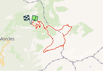
Trail Walking of 9.4 km to be discovered at Vaud, District d'Aigle, Lavey-Morcles. This trail is proposed by rpf.

Description

Au-dessus de Saint-Maurice, au pied de la Dent de Morcles, un sentier délité qui traverse une impressionnante paroi rocheuse, un chemin de crête extraordinaire du Col à la Pointe des Martinets, et un coup d''oeil magique sur le rempart des Muverans !

Départ au-dessus de Saint-Maurice et de Morcles, aux Martinaux, où une barrière toujours fermée interdit l''accès à Rionda et impose trois premiers kilomètres de route sans grand intérêt.
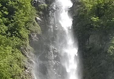
Après Rionda, un passage difficile et spectaculaire pour franchir la paroi rocheuse dominée par la Dent de Morcles.
Retour par le Col des Perris Blancs et la Cabane de la Tourche.

Une balade de  " www.toprando.ch "

Elevation profile

Positioning

Country:
Switzerland
Region :
Vaud
Department/Province :
District d'Aigle
Municipality :
Lavey-Morcles
Location:
Unknown
Start:(UTM)
349677 ; 5119771 (32T) N.

Trails nearby

Trail On foot Evionnaz - Chemin pédestre, région Martigny - Photo
On foot
PRO

On foot

Easy
Evionnaz, Valais/Wallis, Saint-Maurice, Switzerland
14.3 km | 17.1 km-effort
3h 52min
No
Trail On foot Saint-Maurice - Tour des Dents du Midi - Photo
On foot
PRO

On foot

Very difficult
Saint-Maurice, Valais/Wallis, Saint-Maurice, Switzerland
46 km | 88 km-effort
19h 58min
Yes
Trail Walking Saint-Maurice - Tour des dents du midi - Photo
Walking
GhiJoe

Walking

Medium
Saint-Maurice, Valais/Wallis, Saint-Maurice, Switzerland
59 km | 107 km-effort
23h 39min
Yes
Trail Mountain bike Saint-Maurice - Bike32922 - Photo
Mountain bike
GUIDE+

Mountain bike

Very easy
Saint-Maurice, Valais/Wallis, Saint-Maurice, Switzerland
26 km | 41 km-effort
Unknown
Yes
Trail Walking Bex - Bex (Genferseegebiet) - Photo
Walking
GUIDE+

Walking

Very easy
Bex, Vaud, District d'Aigle, Switzerland
10.5 km | 18.6 km-effort
5h 55min
Yes
Trail Walking Saint-Maurice - Abenteuer-Trek in ein unbekanntes Wallis. Mex - Salanfe (Hotel) - Photo
Walking
GUIDE+

Walking

Very easy
Saint-Maurice, Valais/Wallis, Saint-Maurice, Switzerland
9.4 km | 23 km-effort
Unknown
No
Trail Walking Lavey-Morcles - Circuit Lavey-Les-Bains 05.2016 - Photo
Walking
duamerg

Walking

Medium
Lavey-Morcles, Vaud, District d'Aigle, Switzerland
10.6 km | 13.1 km-effort
3h 6min
Yes
Trail Walking Lavey-Morcles - Morcles, La Tourche, Rionda - Photo
Walking
jipi2

Walking

Medium
Lavey-Morcles, Vaud, District d'Aigle, Switzerland
11.2 km | 25 km-effort
5h 3min
Yes
Trail Running Bex - base 1 - Photo
Running
gregory.quin

Running

Very easy
Bex, Vaud, District d'Aigle, Switzerland
10.9 km | 17.3 km-effort
1h 36min
Yes


Close
My subscriptions