Trail Walking Caluire-et-Cuire - A_CALUIRE 69300 St-Clair - Crépieux - Photo

A_CALUIRE 69300 St-Clair - Crépieux

 ANDREJAC
ANDREJAC

User

© OpenStreetMap contributors
Length
Length
10 km
Max alt
Max alt
246 m
Uphill gradient
Uphill gradient
125 m
Km-Effort
Km-Effort  
11.7 km
Min alt
Min alt
166 m
Downhill gradient
Downhill gradient
126 m
Boucle
Boucle
Yes
Creation date :
2015-11-29 00:00:00.0
Updated on :
2015-11-29 00:00:00.0

(1 Reviews)

Walking
Walking
3h00
Difficulty : Easy

Scan this QR Code to open this trail in the SityTrail application

FREE GPS app for hiking

Logo SityTrail SityTrail

IGN / Geographical institutes

Download SityTrail from the App Store Download SityTrail from Google Play

Logo SityTrail SityTrail World

The world is yours!

Download SityTrail from the App Store Download SityTrail from Google Play Download SityTrail on Huawei AppGallery

About

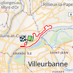
Trail Walking of 10 km to be discovered at Auvergne-Rhône-Alpes, Métropole de Lyon, Caluire-et-Cuire. This trail is proposed by ANDREJAC.

Description

Départ et retour : parking Poumeyrol.
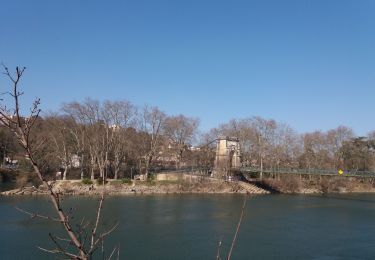
Vers ch de Wette Fays, Gde rue de St Clair, rte de Strasbourg, montée des Soldats, av des Cottages, escalier vers ch de Vassieux, ch des Villas, ch du Poête, esc mt Gruffaz, ch du Panorama, rte de Strasbourg, ch de la Viré, ch de la Buissière, Lycée G. Lamarque, rte de Genève,  ch des Iles, ch entre canal de Miribel et voie ferrée vers Lyon, ch longeant le Rhône, passerelle de la Paix par les escaliers vers rive gauche, puis retour rive droite par le tablier haut de la passerelle, ch sur tunnel Bellevue vers pont Poincaré,  liaison vers av de Poumeyrol, av de Poumeyrol vers parking.

Elevation profile

Positioning

Country:
France
Region :
Auvergne-Rhône-Alpes
Department/Province :
Métropole de Lyon
Municipality :
Caluire-et-Cuire
Location:
Unknown
Start:(UTM)
644685 ; 5072319 (31T) N.

Comments

Please log in to post a review or rate the element


Agréable découverte des villas de Vassieux, et paisible parcours le long du Rhône.


Trails nearby

Trail Mountain bike Collonges-au-Mont-d'Or - Tour du Mont Cindre et Mont Thoux - Photo
Mountain bike
tracegps

Mountain bike

Difficult
(3)
Collonges-au-Mont-d'Or, Auvergne-Rhône-Alpes, Métropole de Lyon, France
25 km | 33 km-effort
1h 40min
Yes
Trail Mountain bike Lyon - Mont Verdun - Photo
Mountain bike
tracegps

Mountain bike

Difficult
(2)
Lyon, Auvergne-Rhône-Alpes, Métropole de Lyon, France
29 km | 37 km-effort
2h 15min
Yes
Trail Walking Lyon - De Place des Archives à Monplaisir - Photo
Walking
Marie-Hélène Luton 2

Walking

Difficult
(1)
Lyon, Auvergne-Rhône-Alpes, Métropole de Lyon, France
11.2 km | 12.9 km-effort
2h 55min
No
Trail Mountain bike Lyon - Monts d'Or_02 - Photo
Mountain bike
philmascio

Mountain bike

Medium
(2)
Lyon, Auvergne-Rhône-Alpes, Métropole de Lyon, France
32 km | 45 km-effort
2h 54min
Yes
Trail Walking Saint-Cyr-au-Mont-d'Or - s3-c_st_cyr_69450_3d_homme_paysage - Photo
Walking
vidal.galaxy

Walking

Medium
(1)
Saint-Cyr-au-Mont-d'Or, Auvergne-Rhône-Alpes, Métropole de Lyon, France
6.6 km | 9.3 km-effort
2h 6min
Yes
Trail Walking Lyon - Fnac - Photo
Walking
ricoux

Walking

Easy
(1)
Lyon, Auvergne-Rhône-Alpes, Métropole de Lyon, France
1.9 km | 2.3 km-effort
18min
No
Trail Walking Lyon - cuire et ile barbe - Photo
Walking
maclobar

Walking

Very difficult
Lyon, Auvergne-Rhône-Alpes, Métropole de Lyon, France
17.8 km | 23 km-effort
5h 16min
No
Trail On foot Lyon - Promenade de Rochecardon - Photo
On foot
PRO

On foot

Easy
Lyon, Auvergne-Rhône-Alpes, Métropole de Lyon, France
5.9 km | 8.5 km-effort
1h 55min
No
Trail Walking Lyon - Vieux Lyon-Mornant 09 et 10 2021 - Photo
Walking
Delahalle

Walking

Very difficult
Lyon, Auvergne-Rhône-Alpes, Métropole de Lyon, France
40 km | 51 km-effort
13h 0min
No


Close
My subscriptions