Trail Other activity Cabriès - Plateau Arbois  - Photo
 Thiste
Thiste

User

© OpenStreetMap contributors
Length
Length
35 km
Max alt
Max alt
252 m
Uphill gradient
Uphill gradient
569 m
Km-Effort
Km-Effort  
43 km
Min alt
Min alt
105 m
Downhill gradient
Downhill gradient
570 m
Boucle
Boucle
Yes
Creation date :
2015-11-28 00:00:00.0
Updated on :
2015-11-28 00:00:00.0

(3 Reviews)

Other activity
Other activity
4h00
Difficulty : Unknown

Scan this QR Code to open this trail in the SityTrail application

FREE GPS app for hiking

Logo SityTrail SityTrail

IGN / Geographical institutes

Download SityTrail from the App Store Download SityTrail from Google Play

Logo SityTrail SityTrail World

The world is yours!

Download SityTrail from the App Store Download SityTrail from Google Play Download SityTrail on Huawei AppGallery

About

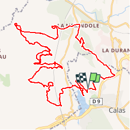
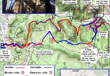
Trail Other activity of 35 km to be discovered at Provence-Alpes-Côte d'Azur, Bouches-du-Rhône, Cabriès. This trail is proposed by Thiste.

Elevation profile

Positioning

Country:
France
Region :
Provence-Alpes-Côte d'Azur
Department/Province :
Bouches-du-Rhône
Municipality :
Cabriès
Location:
Unknown
Start:(UTM)
688794 ; 4815738 (31T) N.

Comments

Please log in to post a review or rate the element


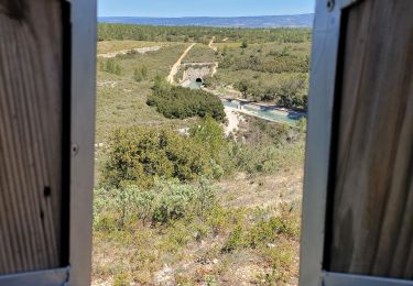
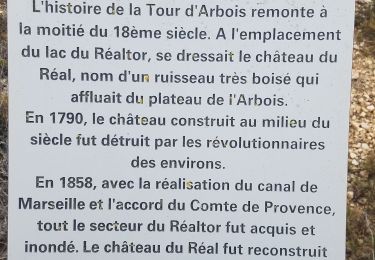
Attention à la cascade à coté de la Maison Arquier et à l'Aqueduc qui sont des lieux de drague et de prostitution : https://lieuxdedrague.fr/lieu-de-drague/cascade-roquefavour-aqueduc/18042 Et attention au parking de la tour d'arbois et à la route de la tour d'arbois également : https://lieuxdedrague.fr/lieu-de-drague/parking-de-l-arbois/43258


De beaux singles ... Un regal


Trails nearby

Trail Running Velaux - Aqueduc de Roquefavour - Velaux - Photo
Running
tracegps

Running

Medium
(2)
Velaux, Provence-Alpes-Côte d'Azur, Bouches-du-Rhône, France
12.4 km | 17.3 km-effort
1h 19min
Yes
Trail Walking Aix-en-Provence - Arbois garde Realtor  - Photo
Walking
Nathy8913

Walking

Very easy
(1)
Aix-en-Provence, Provence-Alpes-Côte d'Azur, Bouches-du-Rhône, France
13 km | 15.4 km-effort
3h 11min
Yes
Trail Walking Cabriès - source infernet - Photo
Walking
coureurdegarrigue

Walking

Easy
(1)
Cabriès, Provence-Alpes-Côte d'Azur, Bouches-du-Rhône, France
17.2 km | 21 km-effort
4h 40min
Yes
Trail Walking Aix-en-Provence - sentier Badaire plateau de l'Arbois - Photo
Walking
GUIDE
amiral13

Walking

Very easy
Aix-en-Provence, Provence-Alpes-Côte d'Azur, Bouches-du-Rhône, France
8.2 km | 10.4 km-effort
2h 3min
Yes
Trail Walking Bouc-Bel-Air - bouc cabries par les crêtes  - Photo
Walking
rvdebouc

Walking

Very easy
(1)
Bouc-Bel-Air, Provence-Alpes-Côte d'Azur, Bouches-du-Rhône, France
3.5 km | 4.7 km-effort
47min
Yes
Trail Mountain bike Cabriès - l'Arbois - Photo
Mountain bike
Miqueou

Mountain bike

Easy
(1)
Cabriès, Provence-Alpes-Côte d'Azur, Bouches-du-Rhône, France
44 km | 52 km-effort
Unknown
Yes
Trail Mountain bike Vitrolles - Vitrolles - Terre Rouge - Photo
Mountain bike
tracegps

Mountain bike

Difficult
Vitrolles, Provence-Alpes-Côte d'Azur, Bouches-du-Rhône, France
5.7 km | 6.6 km-effort
1h 0min
Yes
Trail Walking Aix-en-Provence - Arbois-Aqueduc-tour de guet - Photo
Walking
Berpav

Walking

Medium
Aix-en-Provence, Provence-Alpes-Côte d'Azur, Bouches-du-Rhône, France
16.1 km | 19.5 km-effort
3h 43min
Yes
Trail Walking Vitrolles - 20lm du plateau  - Photo
Walking
samifly51

Walking

Very difficult
Vitrolles, Provence-Alpes-Côte d'Azur, Bouches-du-Rhône, France
18 km | 21 km-effort
2h 58min
Yes


Close
My subscriptions