Trail Walking Murbach - Murbach grand Ballon - Photo

Murbach grand Ballon

© OpenStreetMap contributors
Length
Length
21 km
Max alt
Max alt
1420 m
Uphill gradient
Uphill gradient
1160 m
Km-Effort
Km-Effort  
37 km
Min alt
Min alt
430 m
Downhill gradient
Downhill gradient
1159 m
Boucle
Boucle
Yes
Creation date :
2015-12-24 00:00:00.0
Updated on :
2020-05-30 17:34:08.143

(1 Reviews)

Walking
Walking
6h00
Difficulty : Difficult

Scan this QR Code to open this trail in the SityTrail application

FREE GPS app for hiking

Logo SityTrail SityTrail

IGN / Geographical institutes

Download SityTrail from the App Store Download SityTrail from Google Play

Logo SityTrail SityTrail World

The world is yours!

Download SityTrail from the App Store Download SityTrail from Google Play Download SityTrail on Huawei AppGallery

About

Trail Walking of 21 km to be discovered at Grand Est, Haut-Rhin, Murbach. This trail is proposed by Fourmis.nf.

Description

Randonnée au Grand Ballon de l'ancienne Abbaye de Murbach : 20km, 1400m de denivele, 6h dont 1 heure de pause.
Randonnée qui peut être assez exigeante parfois, prévoir de quoi se couvrir pour se préserver des tiques à certaines périodes
1.Départ du parking de l'Abbaye en direction de la chapelle derrière la mairie.
2.Revenir sur vos pas à la chapelle et poursuivre sur un petit sentier sinuant à travers la forêt, rejoindre les ruines du Hohrupf. point de vue
3.Revenir sur le sentier et rejoindre la bifurcation rencontré plus tôt
4.Prendre la direction du col de Wolfsgrube.
5.Un peu plus loin sur le chemin de la ferme auberge du Gustiberg, on croise une charmante cascade avant de déguster un morceau de tarte. 6.On rejoint rapidement le lac du Ballon. En contournant le lac par la droite on trouve un sentier qui nous amène sur le toit de l'Alsace : le Grand Ballon et ses panorama impressionnant. Le reste est une formalité.
7.En redescendant sur l'auberge du Ballon on trouve un sentier à sa droite qui nous conduit vers le col du Judenhut pour suivre la direction de Murbach.

Elevation profile

Points of interest

Point of interest Murbach - 001 - Photo
Fourmis.nf
MURBACH 

Positioning

Country:
France
Region :
Grand Est
Department/Province :
Haut-Rhin
Municipality :
Murbach
Location:
Unknown
Start:(UTM)
362587 ; 5309392 (32T) N.

Comments

Please log in to post a review or rate the element


Trails nearby

Trail Walking Linthal - Tour de la grande Vallée de Munster (refuge du Hilsen - Munster) - Photo
Walking
tracegps

Walking

Difficult
(1)
Linthal, Grand Est, Haut-Rhin, France
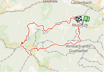
18.1 km | 24 km-effort
5h 0min
No
Trail Walking Lautenbachzell - Le Markstein - Photo
Walking
tracegps

Walking

Difficult
(1)
Lautenbachzell, Grand Est, Haut-Rhin, France
22 km | 35 km-effort
6h 0min
Yes
Trail On foot Goldbach-Altenbach - Firstacker - Willer sur Thur - Photo
On foot
PRO

On foot

Easy
Goldbach-Altenbach, Grand Est, Haut-Rhin, France
7.4 km | 9.6 km-effort
2h 11min
No
Trail Walking Linthal - SityTrail - Remspach-Hilsen - Photo
Walking

Walking

Medium
(1)
Linthal, Grand Est, Haut-Rhin, France
9.9 km | 14.6 km-effort
3h 3min
Yes
Trail Walking Soultz-Haut-Rhin - Rando Marcheurs..04/04_2025 - Photo
Walking
boubou68

Walking

Very difficult
Soultz-Haut-Rhin, Grand Est, Haut-Rhin, France
21 km | 35 km-effort
4h 42min
Yes
Trail Walking Jungholtz - Rando Retrouvailles...01/03/2024.par Jean Marc - Photo
Walking
boubou68

Walking

Very difficult
Jungholtz, Grand Est, Haut-Rhin, France
11.3 km | 19.2 km-effort
1h 35min
Yes
Trail Walking Soultz-Haut-Rhin - Mon tour des Vosges (4 jours) - Photo
Walking
annefrance70

Walking

Very difficult
Soultz-Haut-Rhin, Grand Est, Haut-Rhin, France
71 km | 113 km-effort
25h 38min
Yes
Trail Walking Murbach - La
Walking
boubou68

Walking

Very difficult
Murbach, Grand Est, Haut-Rhin, France
14.7 km | 28 km-effort
4h 3min
Yes
Trail Walking Murbach - Murbach - Photo
Walking
oscar1

Walking

Difficult
Murbach, Grand Est, Haut-Rhin, France
15.4 km | 25 km-effort
4h 25min
Yes


Close
My subscriptions