


tour du pic bertagne

ARPF
User
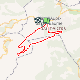

Length
14 km

Max alt
1028 m

Uphill gradient
767 m
Km-Effort
24 km

Min alt
630 m

Downhill gradient
767 m
Boucle
Yes
Creation date :
2015-12-10 00:00:00.0
Updated on :
2015-12-10 00:00:00.0
4h52
Difficulty : Difficult

FREE GPS app for hiking
 SityTrail
IGN / Geographical institutes
SityTrail Plus
The world is yours!
About
Trail Walking of 14 km to be discovered at Provence-Alpes-Côte d'Azur, Var, Plan-d'Aups-Sainte-Baume. This trail is proposed by ARPF.
Description
IE 104 P3 T2
Peux être simplifiée en évitant de passer à la Glacière.
Positioning
Country:
France
Region :
Provence-Alpes-Côte d'Azur
Department/Province :
Var
Municipality :
Plan-d'Aups-Sainte-Baume
Location:
Unknown
Start:(Dec)
Start:(UTM)
719496 ; 4800321 (31T) N.
Comments