Trail Walking Saint-Étienne-de-Saint-Geoirs - rando solidaire 2016 découverte - Photo
© OpenStreetMap contributors
Length
Length
13.5 km
Max alt
Max alt
619 m
Uphill gradient
Uphill gradient
322 m
Km-Effort
Km-Effort  
17.8 km
Min alt
Min alt
395 m
Downhill gradient
Downhill gradient
322 m
Boucle
Boucle
Yes
Creation date :
2016-10-18 00:00:00.0
Updated on :
2016-10-18 00:00:00.0

(0 Reviews)

Walking
Walking
3h49
Difficulty : Easy

Scan this QR Code to open this trail in the SityTrail application

FREE GPS app for hiking

Logo SityTrail SityTrail

IGN / Geographical institutes

Download SityTrail from the App Store Download SityTrail from Google Play

Logo SityTrail SityTrail Plus

The world is yours!

Download SityTrail from the App Store Download SityTrail from Google Play Download SityTrail on Huawei AppGallery

About

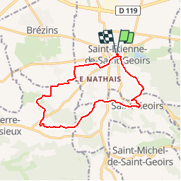
Trail Walking of 13.5 km to be discovered at Auvergne-Rhône-Alpes, Isère, Saint-Étienne-de-Saint-Geoirs. This trail is proposed by raymondfn.

Description

Rando solidaire prévue le dimanche 13 novembre 2016. Organisée par le Foyer Laïque et le club Oxygène de St-Étienne-de-St-Geoirs.
Départ 8H-13H de la Salle des Spectacles  de Saint-Étienne-de-St-Geoirs.

Elevation profile

Positioning

Country:
France
Region :
Auvergne-Rhône-Alpes
Department/Province :
Isère
Municipality :
Saint-Étienne-de-Saint-Geoirs
Location:
Unknown
Start:(UTM)
683612 ; 5023407 (31T) N.


Close
My subscriptions