Trail Walking Wissant - Le Site des 2 Caps - Le Sentier du Phartz et de la Dune d'Aval - Photo

Le Site des 2 Caps - Le Sentier du Phartz et de la Dune d'Aval

 Desrumaux
Desrumaux

User GUIDE

© OpenStreetMap contributors
Length
Length
7.4 km
Max alt
Max alt
30 m
Uphill gradient
Uphill gradient
63 m
Km-Effort
Km-Effort  
8.3 km
Min alt
Min alt
0 m
Downhill gradient
Downhill gradient
64 m
Boucle
Boucle
Yes
Creation date :
2014-12-10 00:00:00.0
Updated on :
2014-12-10 00:00:00.0

(3 Reviews)

Walking
Walking
1h50
Difficulty : Easy

Scan this QR Code to open this trail in the SityTrail application

FREE GPS app for hiking

Logo SityTrail SityTrail

IGN / Geographical institutes

Download SityTrail from the App Store Download SityTrail from Google Play

Logo SityTrail SityTrail World

The world is yours!

Download SityTrail from the App Store Download SityTrail from Google Play Download SityTrail on Huawei AppGallery

About

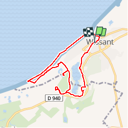
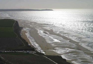
Trail Walking of 7.4 km to be discovered at Hauts-de-France, Pas-de-Calais, Wissant. This trail is proposed by Desrumaux.

Description

Détails de la rando sur TraceGPS.com

http://www.tracegps.com/fr/parcours/circuit3986.htm

Elevation profile

Positioning

Country:
France
Region :
Hauts-de-France
Department/Province :
Pas-de-Calais
Municipality :
Wissant
Location:
Unknown
Start:(UTM)
405854 ; 5637939 (31U) N.

Comments

Please log in to post a review or rate the element


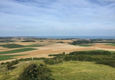
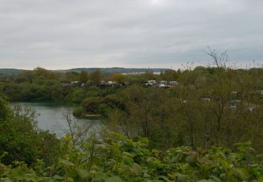
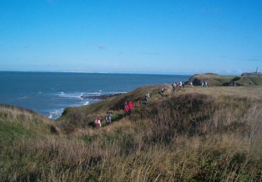
belle rando avec le beau temps.


Attention, sur la plage au retour le chemin est désormais interdit ?? et le front de mer à Wissant est interdit aux chiens, même tenus en laisse ?? sinon très jolie promenade ??


Trails nearby

Trail Walking Wissant - Wissant-Mont de Couple- retour par la plage - Photo
Walking
Vagabond gaumardennais

Walking

Difficult
(1)
Wissant, Hauts-de-France, Pas-de-Calais, France
14.3 km | 0 m-effort
2h 53min
Yes
Trail Walking Wissant - Le Fartz - Photo
Walking
terminio

Walking

Very easy
(1)
Wissant, Hauts-de-France, Pas-de-Calais, France
5.5 km | 6.2 km-effort
1h 29min
Yes
Trail Walking Escalles - Les balcons d'Escalles  - Photo
Walking
tracegps

Walking

Medium
(4)
Escalles, Hauts-de-France, Pas-de-Calais, France
7.8 km | 10.5 km-effort
2h 0min
Yes
Trail Walking Sangatte - Le Site des 2 Caps - Les Falaises du Cap Blanc Nez et le Mont d'Hubert - Photo
Walking
tracegps

Walking

Medium
(3)
Sangatte, Hauts-de-France, Pas-de-Calais, France
11.2 km | 14.7 km-effort
3h 0min
Yes
Trail Walking Tardinghen - Le Site des 2 Caps - Le Sentier des Crans - Photo
Walking
tracegps

Walking

Medium
(2)
Tardinghen, Hauts-de-France, Pas-de-Calais, France
12 km | 14.3 km-effort
3h 0min
Yes
Trail Walking Tardinghen - Sentier du Fartz - Waissant - Photo
Walking
tracegps

Walking

Easy
(1)
Tardinghen, Hauts-de-France, Pas-de-Calais, France
5.1 km | 5.8 km-effort
1h 30min
Yes
Trail Walking Audinghen - Circuit du Cap Gris-Nez  - Photo
Walking
Baltykatt

Walking

Very difficult
(1)
Audinghen, Hauts-de-France, Pas-de-Calais, France
27 km | 31 km-effort
7h 0min
Yes
Trail Walking Audinghen - Circuit du Cap Gris-Nez  - Photo
Walking
tracegps

Walking

Very difficult
(1)
Audinghen, Hauts-de-France, Pas-de-Calais, France
27 km | 31 km-effort
7h 0min
Yes
Trail Walking Tardinghen - Le Site des 2 Caps - Le Sentier des Crans - Photo
Walking
GUIDE
Desrumaux

Walking

Easy
(3)
Tardinghen, Hauts-de-France, Pas-de-Calais, France
12 km | 14.3 km-effort
3h 0min
Yes


Close
My subscriptions