Trail Walking Argelès-sur-Mer - 66 COLLIOURE, Sentier littoral de la crique des Portells à COLLIOURE et retour  - Photo

66 COLLIOURE, Sentier littoral de la crique des Portells à COLLIOURE et retour

 jeff66
jeff66

User

© OpenStreetMap contributors
Length
Length
6.5 km
Max alt
Max alt
58 m
Uphill gradient
Uphill gradient
124 m
Km-Effort
Km-Effort  
8.1 km
Min alt
Min alt
-1 m
Downhill gradient
Downhill gradient
124 m
Boucle
Boucle
Yes
Creation date :
2015-12-20 00:00:00.0
Updated on :
2015-12-20 00:00:00.0

(0 Reviews)

Walking
Walking
1h30
Difficulty : Easy

Scan this QR Code to open this trail in the SityTrail application

FREE GPS app for hiking

Logo SityTrail SityTrail

IGN / Geographical institutes

Download SityTrail from the App Store Download SityTrail from Google Play

Logo SityTrail SityTrail World

The world is yours!

Download SityTrail from the App Store Download SityTrail from Google Play Download SityTrail on Huawei AppGallery

About

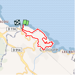
Trail Walking of 6.5 km to be discovered at Occitania, Pyrénées-Orientales, Argelès-sur-Mer. This trail is proposed by jeff66.

Description

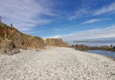
66 COLLIOURE, Sentier littoral de la crique des Portells, calanque et plage de L'Ouille, font d'en Bertrand, forts carré et Rodon, avenue du mirador, rue de San Sébastien, rue Dugommier, rue Dagobert, rue de l'église. Plage St vincent, Al Boramar, rue de la république, rue des palmiers. Parking Du Douy, RD114

Elevation profile

Photos

35 photos in total. Please click on a photo to see them all in the gallery.

Positioning

Country:
France
Region :
Occitania
Department/Province :
Pyrénées-Orientales
Municipality :
Argelès-sur-Mer
Location:
Unknown
Start:(UTM)
505519 ; 4709053 (31T) N.

Trails nearby

Trail Mountain bike Argelès-sur-Mer - la dujardin - Photo
Mountain bike
fine66

Mountain bike

Very easy
(5)
Argelès-sur-Mer, Occitania, Pyrénées-Orientales, France
11.6 km | 18.7 km-effort
1h 11min
No
Trail Walking Port-Vendres - Le sentier des douaniers (Port-Vendres) - Photo
Walking
tracegps

Walking

Medium
(5)
Port-Vendres, Occitania, Pyrénées-Orientales, France
14.5 km | 19.1 km-effort
4h 0min
Yes
Trail Walking Collioure - Collioure-le racou - Photo
Walking
jeromelacoste

Walking

Medium
(1)
Collioure, Occitania, Pyrénées-Orientales, France
7.2 km | 9.3 km-effort
2h 1min
Yes
Trail Walking Argelès-sur-Mer - 66 ARGELES SUR MER - mas Christine, promenade dans les Albères, par les pistes,sentiers, entre les chênes lièges - Photo
Walking
jeff66

Walking

Medium
(2)
Argelès-sur-Mer, Occitania, Pyrénées-Orientales, France
7.4 km | 9.8 km-effort
1h 28min
Yes
Trail Walking Collioure - 66 COLLIOURE - les balcons de Madeloc - circuit de la tour et des fortifications  - Photo
Walking
jeff66

Walking

Difficult
(1)
Collioure, Occitania, Pyrénées-Orientales, France
9.3 km | 14.9 km-effort
2h 4min
Yes
Trail Walking Argelès-sur-Mer - ARGELES SUR MER 66 - VALMY - tour de la Massane - les Colomates  - Photo
Walking
jeff66

Walking

Difficult
(2)
Argelès-sur-Mer, Occitania, Pyrénées-Orientales, France
22 km | 34 km-effort
5h 35min
Yes
Trail Walking Port-Vendres - PORT-VENDRES 66 - Sentier littoral jusqu'à BANYULS-SUR-MER - retour par l'arrière pays et le vignoble - Photo
Walking
jeff66

Walking

Medium
(2)
Port-Vendres, Occitania, Pyrénées-Orientales, France
10.1 km | 14 km-effort
2h 21min
Yes
Trail Walking Collioure - COLLIOURE 66 - Ermitage ND de consolation - tour MADELOC - Photo
Walking
jeff66

Walking

Difficult
(4)
Collioure, Occitania, Pyrénées-Orientales, France
14.7 km | 23 km-effort
3h 41min
Yes
Trail Walking Argelès-sur-Mer - Racou- Colioure 06-2014 - Photo
Walking
phi14

Walking

Very easy
(1)
Argelès-sur-Mer, Occitania, Pyrénées-Orientales, France
5 km | 6.5 km-effort
1h 36min
No


Close
My subscriptions