Trail Walking Saint-Cyr-sur-le-Rhône - NouveMarche de vilage 17 km   - Photo
© OpenStreetMap contributors
Length
Length
17.5 km
Max alt
Max alt
381 m
Uphill gradient
Uphill gradient
427 m
Km-Effort
Km-Effort  
23 km
Min alt
Min alt
142 m
Downhill gradient
Downhill gradient
429 m
Boucle
Boucle
Yes
Creation date :
2016-01-17 00:00:00.0
Updated on :
2016-01-17 00:00:00.0

(1 Reviews)

Walking
Walking
5h00
Difficulty : Difficult

Scan this QR Code to open this trail in the SityTrail application

FREE GPS app for hiking

Logo SityTrail SityTrail

IGN / Geographical institutes

Download SityTrail from the App Store Download SityTrail from Google Play

Logo SityTrail SityTrail World

The world is yours!

Download SityTrail from the App Store Download SityTrail from Google Play Download SityTrail on Huawei AppGallery

About

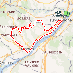
Trail Walking of 17.5 km to be discovered at Auvergne-Rhône-Alpes, Rhône, Saint-Cyr-sur-le-Rhône. This trail is proposed by servemichel.

Description

La boucle des vignes . Parcours N 3.

Elevation profile

Positioning

Country:
France
Region :
Auvergne-Rhône-Alpes
Department/Province :
Rhône
Municipality :
Saint-Cyr-sur-le-Rhône
Location:
Unknown
Start:(UTM)
644852 ; 5041636 (31T) N.

Comments

Please log in to post a review or rate the element


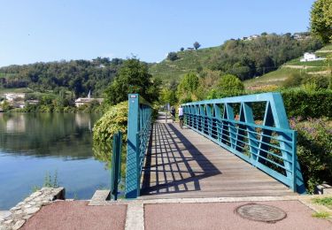
Très bien mise à part le début sans grand intérêt et surtout la fin sur une route interminable au dessus de l'autoroute. Rando variée, traversant les vignes à flanc de colline, la campagne vallonnée et des jolis chemins serpentant dans des zones boisées.


Trails nearby

Trail On foot Jardin - Jardin - 10,7 km - 255 m de dénivelé - 3h30 - Photo
On foot
Clubléorando

On foot

Medium
(1)
Jardin, Auvergne-Rhône-Alpes, Isère, France
10.7 km | 14.1 km-effort
3h 30min
Yes
Trail Mountain bike Serpaize - canyon  de Serpaize - Photo
Mountain bike
marc6262

Mountain bike

Easy
(1)
Serpaize, Auvergne-Rhône-Alpes, Isère, France
13.4 km | 16.8 km-effort
1h 46min
Yes
Trail Walking Saint-Romain-en-Gal - le grisard - Photo
Walking
servemichel

Walking

Medium
(1)
Saint-Romain-en-Gal, Auvergne-Rhône-Alpes, Rhône, France
5.3 km | 7.9 km-effort
1h 48min
Yes
Trail Hybrid bike Vienne - ViaRhona Vienne Coux 150km - Photo
Hybrid bike
GUIDE
thonyc

Hybrid bike

Medium
Vienne, Auvergne-Rhône-Alpes, Isère, France
146 km | 162 km-effort
Unknown
No
Trail Walking Vienne - 38-Vienne-visite-4.5km-mai21 - Photo
Walking
SyMA

Walking

Easy
Vienne, Auvergne-Rhône-Alpes, Isère, France
4.6 km | 5.2 km-effort
1h 47min
Yes
Trail Walking Reventin-Vaugris - REVENTIN 18 JC - Photo
Walking
Clubléorando

Walking

Very easy
(1)
Reventin-Vaugris, Auvergne-Rhône-Alpes, Isère, France
7.3 km | 10.5 km-effort
2h 12min
Yes
Trail Walking Reventin-Vaugris - REVENTIN VAUGRIS 2 JC - Photo
Walking
Clubléorando

Walking

Very easy
(1)
Reventin-Vaugris, Auvergne-Rhône-Alpes, Isère, France
12.9 km | 17.8 km-effort
3h 45min
Yes
Trail Walking Ampuis - AMPUIS JC - Photo
Walking
Clubléorando

Walking

Very easy
(1)
Ampuis, Auvergne-Rhône-Alpes, Rhône, France
9.7 km | 12.1 km-effort
3h 10min
Yes
Trail Mountain bike Reventin-Vaugris - Écureuil 2013 - Photo
Mountain bike
marc6262

Mountain bike

Difficult
(1)
Reventin-Vaugris, Auvergne-Rhône-Alpes, Isère, France
30 km | 40 km-effort
2h 34min
Yes


Close
My subscriptions