Trail Walking Ermenonville - Chaalis 13km - Photo
 vitius
vitius

User

© OpenStreetMap contributors
Length
Length
13.4 km
Max alt
Max alt
127 m
Uphill gradient
Uphill gradient
181 m
Km-Effort
Km-Effort  
15.8 km
Min alt
Min alt
63 m
Downhill gradient
Downhill gradient
183 m
Boucle
Boucle
Yes
Creation date :
2019-05-07 16:39:36.093
Updated on :
2023-02-11 15:27:32.577

(3 Reviews)

Walking
Walking
3h25
Difficulty : Easy

Scan this QR Code to open this trail in the SityTrail application

FREE GPS app for hiking

Logo SityTrail SityTrail

IGN / Geographical institutes

Download SityTrail from the App Store Download SityTrail from Google Play

Logo SityTrail SityTrail World

The world is yours!

Download SityTrail from the App Store Download SityTrail from Google Play Download SityTrail on Huawei AppGallery

About

Trail Walking of 13.4 km to be discovered at Hauts-de-France, Oise, Ermenonville. This trail is proposed by vitius.

Description

Circuit facile de 13,3km

Elevation profile

Positioning

Country:
France
Region :
Hauts-de-France
Department/Province :
Oise
Municipality :
Ermenonville
Location:
Unknown
Start:(UTM)
477638 ; 5441466 (31U) N.

Comments

Please log in to post a review or rate the element


Très intéressant merci


excellent


Trails nearby

Trail Walking Ermenonville - SM_ERMENONVILLE CHATEAU_NORD_8.1Km - Photo
Walking
GR77LP

Walking

Easy
(1)
Ermenonville, Hauts-de-France, Oise, France
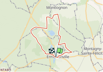
8.1 km | 9.5 km-effort
2h 12min
Yes
Trail Walking Fontaine-Chaalis - Abbaye de Chaalis+fiche+GPX_ 7,8Km_SM - Photo
Walking

Walking

Medium
(8)
Fontaine-Chaalis, Hauts-de-France, Oise, France
7.9 km | 9 km-effort
2h 2min
Yes
Trail Walking Ver-sur-Launette - SM_VER-sur-LAUNETTE_8.5Km - Photo
Walking
GR77LP

Walking

Medium
(7)
Ver-sur-Launette, Hauts-de-France, Oise, France
8.5 km | 9.6 km-effort
2h 6min
Yes
Trail Walking Fontaine-Chaalis - Abbaye de Chaalis Supermini Rando - Photo
Walking

Walking

Medium
(6)
Fontaine-Chaalis, Hauts-de-France, Oise, France
8.5 km | 9.5 km-effort
1h 56min
Yes
Trail Walking Ermenonville - Ermenonville Chateau 6,3 Km - Photo
Walking
GR77LP

Walking

Medium
(4)
Ermenonville, Hauts-de-France, Oise, France
5.8 km | 6.8 km-effort
1h 32min
Yes
Trail Walking Montagny-Sainte-Félicité - SM_MONTAGNY_Ste-FELECITE_8.5Km - Photo
Walking
GR77LP

Walking

Medium
(6)
Montagny-Sainte-Félicité, Hauts-de-France, Oise, France
8.6 km | 10.1 km-effort
2h 12min
Yes
Trail Walking Versigny - SM_VERSIGNY-OUEST_7.5Km - Photo
Walking
GR77LP

Walking

Medium
(5)
Versigny, Hauts-de-France, Oise, France
7.5 km | 8.1 km-effort
2h 57min
Yes
Trail Walking Ver-sur-Launette - SM_LOISY_8.5Km - Photo
Walking
GR77LP

Walking

Medium
(2)
Ver-sur-Launette, Hauts-de-France, Oise, France
8.7 km | 9.7 km-effort
2h 12min
Yes
Trail Walking Othis - SM_BEAUMARCHAIS_8.2Km - Photo
Walking
GR77LP

Walking

Medium
(4)
Othis, Ile-de-France, Seine-et-Marne, France
8.3 km | 9.1 km-effort
2h 3min
Yes


Close
My subscriptions