Trail Walking Yvetot - Yvetot Caudebec en Caux - Photo

Yvetot Caudebec en Caux

© OpenStreetMap contributors
Length
Length
18.1 km
Max alt
Max alt
150 m
Uphill gradient
Uphill gradient
272 m
Km-Effort
Km-Effort  
22 km
Min alt
Min alt
9 m
Downhill gradient
Downhill gradient
405 m
Boucle
Boucle
No
Creation date :
2016-03-23 00:00:00.0
Updated on :
2016-03-23 00:00:00.0

(0 Reviews)

Walking
Walking
4h44
Difficulty : Easy

Scan this QR Code to open this trail in the SityTrail application

FREE GPS app for hiking

Logo SityTrail SityTrail

IGN / Geographical institutes

Download SityTrail from the App Store Download SityTrail from Google Play

Logo SityTrail SityTrail World

The world is yours!

Download SityTrail from the App Store Download SityTrail from Google Play Download SityTrail on Huawei AppGallery

About

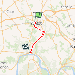
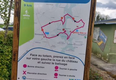
Trail Walking of 18.1 km to be discovered at Normandy, Seine-Maritime, Yvetot. This trail is proposed by Aclarando.

Description

Départ près de la gare d'Yvetot
randonnée en antenne, utilisation du car pour le retour

Elevation profile

Positioning

Country:
France
Region :
Normandy
Department/Province :
Seine-Maritime
Municipality :
Yvetot
Location:
Unknown
Start:(UTM)
337469 ; 5499069 (31U) N.

Trails nearby

Trail On foot Ectot-lès-Baons - Circuit d'Ectot-les-Baons - Relais du Gal - Photo
On foot
PRO

On foot

Easy
Ectot-lès-Baons, Normandy, Seine-Maritime, France
6.7 km | 7.2 km-effort
1h 37min
No
Trail Walking Rocquefort - rocquefort - Photo
Walking
nicole.reine@wanadoo.fr

Walking

Medium
Rocquefort, Normandy, Seine-Maritime, France
8 km | 9.3 km-effort
2h 31min
Yes
Trail On foot Rocquefort - 211c - Photo
On foot
PRO

On foot

Easy
Rocquefort, Normandy, Seine-Maritime, France
12.9 km | 14.5 km-effort
3h 17min
No
Trail On foot Yvetot - FR-211a - Photo
On foot
PRO

On foot

Easy
Yvetot, Normandy, Seine-Maritime, France
9 km | 10.3 km-effort
2h 21min
No
Trail Walking Touffreville-la-Corbeline - Touffreville la Corbeline - Photo
Walking
MichelRando7656

Walking

Difficult
(2)
Touffreville-la-Corbeline, Normandy, Seine-Maritime, France
12.4 km | 14.4 km-effort
3h 20min
Yes
Trail On foot Étoutteville - La voie romaine - Photo
On foot
PRO

On foot

Easy
Étoutteville, Normandy, Seine-Maritime, France
7.2 km | 8.2 km-effort
1h 51min
Yes
Trail Hybrid bike Yvetot - Au fil de la Risle - Photo
Hybrid bike
ves

Hybrid bike

Medium
Yvetot, Normandy, Seine-Maritime, France
178 km | 208 km-effort
Unknown
No
Trail Walking Yvetot - Les Fonds de Saint-Clair - Photo
Walking

Walking

Easy
Yvetot, Normandy, Seine-Maritime, France
13.7 km | 15.7 km-effort
3h 27min
Yes
Trail Mountain bike Yvetot - Yvetot St Wandrille - Photo
Mountain bike
ves

Mountain bike

Yvetot, Normandy, Seine-Maritime, France
36 km | 46 km-effort
2h 12min
No


Close
My subscriptions