Trail Walking Puyloubier - traversée St Ser, le pic des Mouches, Puyloubier - Photo

traversée St Ser, le pic des Mouches, Puyloubier

 amiral13
amiral13

User GUIDE

© OpenStreetMap contributors
Length
Length
8.4 km
Max alt
Max alt
998 m
Uphill gradient
Uphill gradient
601 m
Km-Effort
Km-Effort  
16.5 km
Min alt
Min alt
369 m
Downhill gradient
Downhill gradient
635 m
Boucle
Boucle
No
Creation date :
2016-06-03 00:00:00.0
Updated on :
2016-06-03 00:00:00.0

(1 Reviews)

Walking
Walking
5h47
Difficulty : Difficult

Scan this QR Code to open this trail in the SityTrail application

FREE GPS app for hiking

Logo SityTrail SityTrail

IGN / Geographical institutes

Download SityTrail from the App Store Download SityTrail from Google Play

Logo SityTrail SityTrail World

The world is yours!

Download SityTrail from the App Store Download SityTrail from Google Play Download SityTrail on Huawei AppGallery

About

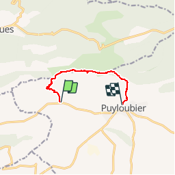
Trail Walking of 8.4 km to be discovered at Provence-Alpes-Côte d'Azur, Bouches-du-Rhône, Puyloubier. This trail is proposed by amiral13.

Description

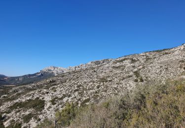
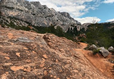
la montée s'effectue par le tracé rouge avec quelques passages équipés de chaines qui peuvent impressionner les moins téméraires. Au niveau du point 3 nous avons choisi de suivre le rouge pointillé qui vous amène directement au pic des mouches; le rouge lui se dirige vers le col de Saint Ser. en quittant le pic des mouches faire un léger détour par le garagai de cagoloup puis par la grotte de la cheminée. On suivra ensuite un bon sentier jusqu'à l'oratoire de Malivert. De là, le sentier est moins confortable jusqu'à Puyloubier. prévoir une voiture ou d'un petit footing courrez récupérer votre véhicule. pour descente on peut aussi suivre le tracée vert qui descend plein sud au droit du garagai (cairn) la descente sans grosse difficulté demande un peu d'attention; l'avantage est qu'il vous ramènera directement à la voiture.

Elevation profile

Photos

Points of interest

Point of interest Puyloubier - chaines - Photo
amiral13
PUYLOUBIER 

Positioning

Country:
France
Region :
Provence-Alpes-Côte d'Azur
Department/Province :
Bouches-du-Rhône
Municipality :
Puyloubier
Location:
Unknown
Start:(UTM)
713607 ; 4822851 (31T) N.

Comments

Please log in to post a review or rate the element


Magnifique


Trails nearby

Trail Walking Saint-Antonin-sur-Bayon - Ste Victoire - Le Garagaï - Photo
Walking
ETMU5496

Walking

Difficult
(1)
Saint-Antonin-sur-Bayon, Provence-Alpes-Côte d'Azur, Bouches-du-Rhône, France
15.8 km | 28 km-effort
4h 36min
Yes
Trail Walking Saint-Antonin-sur-Bayon - 2023-02-10 Sainte Victoire Bau des Vespres - Photo
Walking
GUIDE
Kargil

Walking

Difficult
Saint-Antonin-sur-Bayon, Provence-Alpes-Côte d'Azur, Bouches-du-Rhône, France
10 km | 18.8 km-effort
3h 30min
Yes
Trail Walking Puyloubier - 2023-02-03 Sainte Victoire - Le Pic des Mouches - Photo
Walking
GUIDE
Kargil

Walking

Difficult
Puyloubier, Provence-Alpes-Côte d'Azur, Bouches-du-Rhône, France
10 km | 19 km-effort
3h 10min
Yes
Trail Walking Saint-Antonin-sur-Bayon - pas du clapier et tracé vert - Photo
Walking
GUIDE
amiral13

Walking

Difficult
Saint-Antonin-sur-Bayon, Provence-Alpes-Côte d'Azur, Bouches-du-Rhône, France
10.5 km | 21 km-effort
5h 24min
Yes
Trail Walking Puyloubier - Le pic des Mouches par le col de St Ser - Photo
Walking
GUIDE
amiral13

Walking

Difficult
Puyloubier, Provence-Alpes-Côte d'Azur, Bouches-du-Rhône, France
6.5 km | 14.7 km-effort
3h 40min
Yes
Trail Walking Saint-Antonin-sur-Bayon - de la maison de Ste Victoire à l'ermitage de St Ser en passant par le pas de la torque - Photo
Walking
GUIDE
amiral13

Walking

Medium
Saint-Antonin-sur-Bayon, Provence-Alpes-Côte d'Azur, Bouches-du-Rhône, France
8.8 km | 16.3 km-effort
6h 17min
No
Trail Walking Puyloubier - Puyloubier Roland - Photo
Walking
gaggiroland

Walking

Medium
(1)
Puyloubier, Provence-Alpes-Côte d'Azur, Bouches-du-Rhône, France
12.8 km | 17.1 km-effort
6h 28min
Yes
Trail Walking Saint-Antonin-sur-Bayon - Le Garagaï-Ste Victoire-04-05-22 - Photo
Walking
Christiancordin

Walking

Difficult
Saint-Antonin-sur-Bayon, Provence-Alpes-Côte d'Azur, Bouches-du-Rhône, France
11.7 km | 21 km-effort
4h 31min
Yes
Trail Walking Saint-Antonin-sur-Bayon - sainte victoire - Photo
Walking
EricLucchesi

Walking

Very difficult
Saint-Antonin-sur-Bayon, Provence-Alpes-Côte d'Azur, Bouches-du-Rhône, France
10.2 km | 20 km-effort
4h 56min
Yes


Close
My subscriptions