Trail Walking Moissac - CHEMIN CLUNISIEN de GUYENNE GASCOGNE - Photo

CHEMIN CLUNISIEN de GUYENNE GASCOGNE

 Gemi47
Gemi47

User

© OpenStreetMap contributors
Length
Length
105 km
Max alt
Max alt
191 m
Uphill gradient
Uphill gradient
2174 m
Km-Effort
Km-Effort  
134 km
Min alt
Min alt
39 m
Downhill gradient
Downhill gradient
2204 m
Boucle
Boucle
No
Creation date :
2016-04-07 00:00:00.0
Updated on :
2016-04-07 00:00:00.0

(1 Reviews)

Walking
Walking
27h35
Difficulty : Easy

Scan this QR Code to open this trail in the SityTrail application

FREE GPS app for hiking

Logo SityTrail SityTrail

IGN / Geographical institutes

Download SityTrail from the App Store Download SityTrail from Google Play

Logo SityTrail SityTrail World

The world is yours!

Download SityTrail from the App Store Download SityTrail from Google Play Download SityTrail on Huawei AppGallery

About

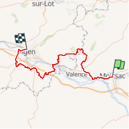
Trail Walking of 105 km to be discovered at Occitania, Tarn-et-Garonne, Moissac. This trail is proposed by Gemi47.

Elevation profile

Photos

Points of interest

Point of interest Saint-Maurin - ABBAYE de SAINT-MAURIN  - Photo
Gemi47
Point of interest Saint-Maurin - MOULIN de FERRUSSAC - Photo
Gemi47
SAINT-MAURIN 
Point of interest Puymirol - Bastide de Puymirol - Photo
Gemi47
Point of interest Saint-Maurin - Eglise St Martin d'ANGLARS - Photo
Gemi47
Point of interest Montjoi - BASTIDE de MONTJOI - Photo
Gemi47
Point of interest Puymirol - Chateau de TAYRAC - Photo
Gemi47
Point of interest Castelsagrat - Eglise N?D de l'Assomption - Photo
Gemi47
Point of interest Boudou - POINT de VUE - Photo
Gemi47
BOUDOU 
Point of interest Moissac - ABBAYE de MOISSAC - Photo
Gemi47
Point of interest Roquefort - CHATEAU de ROQUEFORT - Photo
Gemi47
Point of interest Layrac - PRIEURE - Photo
Gemi47
LAYRAC 
Point of interest Moirax - PRIEURE - Photo
Gemi47
MOIRAX 
Point of interest Aubiac - Chateau fort - Photo
Gemi47
AUBIAC 
Point of interest Goudourville - Chataeu fort - Photo
Gemi47
GOUDOURVILLE 
Point of interest Caudecoste - Caudecoste - Photo
Gemi47
CAUDECOSTE 

Positioning

Country:
France
Region :
Occitania
Department/Province :
Tarn-et-Garonne
Municipality :
Moissac
Location:
Unknown
Start:(UTM)
346695 ; 4885358 (31T) N.

Comments

Please log in to post a review or rate the element


Trails nearby

Trail On foot Moissac - Les Anciens Chemin de Halage - Photo
On foot
PRO

On foot

Easy
Moissac, Occitania, Tarn-et-Garonne, France
6 km | 6.5 km-effort
1h 28min
No
Trail Mountain bike Moissac - Rando VTT L'Ascension sur les coteaux de Moissac - Photo
Mountain bike
simon32

Mountain bike

Medium
(1)
Moissac, Occitania, Tarn-et-Garonne, France
28 km | 34 km-effort
2h 15min
Yes
Trail Bicycle tourism Moissac - Moissac-Montauban - Photo
Bicycle tourism
ilur56

Bicycle tourism

Medium
Moissac, Occitania, Tarn-et-Garonne, France
38 km | 41 km-effort
3h 0min
No
Trail Walking Moissac - moissac auvillar - Photo
Walking
fab0202

Walking

Difficult
Moissac, Occitania, Tarn-et-Garonne, France
23 km | 29 km-effort
6h 32min
No
Trail Walking Moissac - Tronçon St Jacques moissac auvillar  - Photo
Walking
choubaka77

Walking

Very difficult
Moissac, Occitania, Tarn-et-Garonne, France
25 km | 31 km-effort
7h 4min
No
Trail Walking Moissac - CC_Velay_EB_18_Moissac_St-Antoine_20080818 - Photo
Walking
patrickdanilo

Walking

Easy
Moissac, Occitania, Tarn-et-Garonne, France
30 km | 38 km-effort
8h 35min
No
Trail Walking Moissac - le canal a Moissac  - Photo
Walking
jgu5108

Walking

Easy
Moissac, Occitania, Tarn-et-Garonne, France
10.2 km | 11.2 km-effort
2h 22min
No
Trail Cycle Moissac - de Moissac à Cahors - Photo
Cycle
destras

Cycle

Medium
Moissac, Occitania, Tarn-et-Garonne, France
66 km | 77 km-effort
3h 10min
No
Trail Other activity Moissac - 2014SentierClunisienMoissacMoiraxAgen15Septembre - Photo
Other activity
Gemi47

Other activity

Very easy
(1)
Moissac, Occitania, Tarn-et-Garonne, France
105 km | 134 km-effort
Unknown
No


Close
My subscriptions