Trail Walking Saint-Valérien - Source de l'Orvanne - Photo
© OpenStreetMap contributors
Length
Length
11.3 km
Max alt
Max alt
174 m
Uphill gradient
Uphill gradient
87 m
Km-Effort
Km-Effort  
12.5 km
Min alt
Min alt
144 m
Downhill gradient
Downhill gradient
88 m
Boucle
Boucle
Yes
Creation date :
2016-05-08 00:00:00.0
Updated on :
2016-05-08 00:00:00.0

(0 Reviews)

Walking
Walking
2h47
Difficulty : Easy

Scan this QR Code to open this trail in the SityTrail application

FREE GPS app for hiking

Logo SityTrail SityTrail

IGN / Geographical institutes

Download SityTrail from the App Store Download SityTrail from Google Play

Logo SityTrail SityTrail World

The world is yours!

Download SityTrail from the App Store Download SityTrail from Google Play Download SityTrail on Huawei AppGallery

About

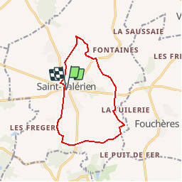
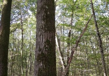
Trail Walking of 11.3 km to be discovered at Bourgogne-Franche-Comté, Yonne, Saint-Valérien. This trail is proposed by micheljannot.

Description

circuit balisé par Comité FFRP
sans description sur topoguide (ancien PR40 de "L'Yonne à pied")

Elevation profile

Positioning

Country:
France
Region :
Bourgogne-Franche-Comté
Department/Province :
Yonne
Municipality :
Saint-Valérien
Location:
Unknown
Start:(UTM)
507077 ; 5336222 (31U) N.

Trails nearby

Trail Walking Villeneuve-la-Dondagre - Villages du Gâtinais en Bourgogne - Photo
Walking
micheljannot

Walking

Easy
Villeneuve-la-Dondagre, Bourgogne-Franche-Comté, Yonne, France
14.8 km | 16.1 km-effort
3h 47min
Yes
Trail Mountain bike Saint-Valérien - Vallée de l'Orvane 1 - Photo
Mountain bike
Yannick89

Mountain bike

Very easy
Saint-Valérien, Bourgogne-Franche-Comté, Yonne, France
35 km | 38 km-effort
3h 14min
No
Trail Walking Saint-Valérien - Saint-Valerien 230219 - Photo
Walking
Specialized77

Walking

Very easy
Saint-Valérien, Bourgogne-Franche-Comté, Yonne, France
10.7 km | 11.7 km-effort
3h 0min
Yes
Trail Geocaching Villeneuve-la-Dondagre - 221112 Villeneuve la Dondagre-02 (geocaching) - Photo
Geocaching
Specialized77

Geocaching

Easy
Villeneuve-la-Dondagre, Bourgogne-Franche-Comté, Yonne, France
8.3 km | 9.1 km-effort
3h 19min
Yes
Trail Geocaching Villeneuve-la-Dondagre - 221026 Villeneuve la D geocaching - Photo
Geocaching
Specialized77

Geocaching

Easy
Villeneuve-la-Dondagre, Bourgogne-Franche-Comté, Yonne, France
10.3 km | 11.4 km-effort
5h 43min
Yes
Trail Walking Villeneuve-la-Dondagre - Villages du Gâtinais en Bourgogne - Photo
Walking
micheljannot

Walking

Easy
Villeneuve-la-Dondagre, Bourgogne-Franche-Comté, Yonne, France
14.7 km | 16.1 km-effort
3h 34min
Yes
Trail Walking La Belliole - Source du Lunain - Photo
Walking
micheljannot

Walking

Easy
La Belliole, Bourgogne-Franche-Comté, Yonne, France
18.5 km | 21 km-effort
4h 32min
Yes
Trail Walking Villebougis - Villebougie  - Photo
Walking
ulysse46

Walking

Very easy
Villebougis, Bourgogne-Franche-Comté, Yonne, France
7.8 km | 8.9 km-effort
2h 16min
Yes
Trail Walking Montacher-Villegardin - montacher - Photo
Walking
Domi1956

Walking

Difficult
Montacher-Villegardin, Bourgogne-Franche-Comté, Yonne, France
15 km | 16.4 km-effort
4h 55min
Yes


Close
My subscriptions