Trail Walking Saint-André-de-Lancize - Les Ayres - Col d'Uglas - Photo
© OpenStreetMap contributors
Length
Length
21 km
Max alt
Max alt
957 m
Uphill gradient
Uphill gradient
781 m
Km-Effort
Km-Effort  
32 km
Min alt
Min alt
509 m
Downhill gradient
Downhill gradient
870 m
Boucle
Boucle
No
Creation date :
2016-06-10 00:00:00.0
Updated on :
2020-02-13 10:49:56.055

(0 Reviews)

Walking
Walking
7h28
Difficulty : Medium

Scan this QR Code to open this trail in the SityTrail application

FREE GPS app for hiking

Logo SityTrail SityTrail

IGN / Geographical institutes

Download SityTrail from the App Store Download SityTrail from Google Play

Logo SityTrail SityTrail World

The world is yours!

Download SityTrail from the App Store Download SityTrail from Google Play Download SityTrail on Huawei AppGallery

About

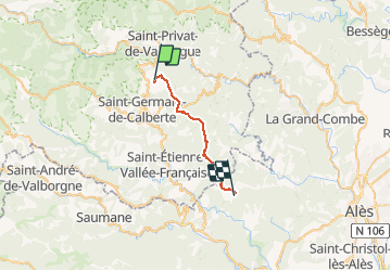
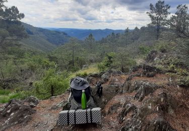
Trail Walking of 21 km to be discovered at Occitania, Lozère, Saint-André-de-Lancize. This trail is proposed by jeanluc.smets.

Description

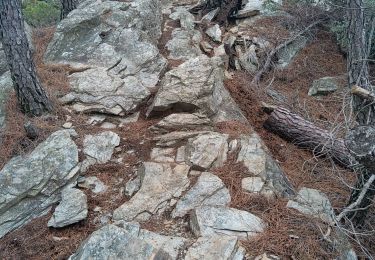
En réalité la randonnée commence au gîte de Valès, avec une belle montée de 1,3 km et 280m de dénivelé jusqu'aux Ayres. Elle se termine au gîte de Mazel à 1 km en desssous du col d'Uglas.

Elevation profile

Positioning

Country:
France
Region :
Occitania
Department/Province :
Lozère
Municipality :
Saint-André-de-Lancize
Location:
Unknown
Start:(Dec)
Start:(UTM)
565895 ; 4899379 (31T) N.

Trails nearby

Trail Walking Saint-Germain-de-Calberte - Stevenson Saint Germain de Calberte Saint Jean du Gard - Photo
Walking
GUIDE
nadinebondoux

Walking

Difficult
Saint-Germain-de-Calberte, Occitania, Lozère, France
20 km | 28 km-effort
5h 53min
No
Trail On foot Saint-Germain-de-Calberte - Sentier des Rocs de Galta - Photo
On foot
PRO

On foot

Easy
Saint-Germain-de-Calberte, Occitania, Lozère, France
5.4 km | 8 km-effort
1h 49min
Yes
Trail Walking Saint-Germain-de-Calberte - st germain de calberte - Photo
Walking
toinou30

Walking

Very difficult
Saint-Germain-de-Calberte, Occitania, Lozère, France
18.4 km | 28 km-effort
6h 25min
Yes
Trail On foot Saint-Germain-de-Calberte - La Flandonenque - Photo
On foot
PRO

On foot

Easy
Saint-Germain-de-Calberte, Occitania, Lozère, France
9.2 km | 13.1 km-effort
2h 57min
Yes
Trail Mountain bike Saint-Germain-de-Calberte - St Germain de Calberte - St Jean du Gard - Photo
Mountain bike
JeanPierreNancy

Mountain bike

Difficult
(1)
Saint-Germain-de-Calberte, Occitania, Lozère, France
32 km | 44 km-effort
2h 46min
No
Trail Walking Saint-André-de-Lancize - Signal de Ventavon - Photo
Walking
oduriez

Walking

Easy
Saint-André-de-Lancize, Occitania, Lozère, France
13.8 km | 21 km-effort
4h 2min
Yes
Trail Walking Saint-Germain-de-Calberte - Gard  - Photo
Walking
jeanjean35

Walking

Very difficult
Saint-Germain-de-Calberte, Occitania, Lozère, France
22 km | 33 km-effort
6h 33min
No
Trail Walking Saint-Germain-de-Calberte - 7e étape et dernière Stevenson - Photo
Walking
Melifera

Walking

Medium
Saint-Germain-de-Calberte, Occitania, Lozère, France
27 km | 39 km-effort
6h 33min
No
Trail Walking Saint-Germain-de-Calberte - Sain Germain de Calberte - Saint Jean du Gard - Photo
Walking
ploizon

Walking

Medium
Saint-Germain-de-Calberte, Occitania, Lozère, France
22 km | 32 km-effort
5h 15min
No


Close
My subscriptions