Trail Running Coursegoules - 2 ème et 3 ème relais cipieres  - Photo
 guess
guess

User

© OpenStreetMap contributors
Length
Length
36 km
Max alt
Max alt
1258 m
Uphill gradient
Uphill gradient
1660 m
Km-Effort
Km-Effort  
59 km
Min alt
Min alt
462 m
Downhill gradient
Downhill gradient
1883 m
Boucle
Boucle
No
Creation date :
2016-06-18 00:00:00.0
Updated on :
2016-06-18 00:00:00.0

(1 Reviews)

Running
Running
7h13
Difficulty : Difficult

Scan this QR Code to open this trail in the SityTrail application

FREE GPS app for hiking

Logo SityTrail SityTrail

IGN / Geographical institutes

Download SityTrail from the App Store Download SityTrail from Google Play

Logo SityTrail SityTrail World

The world is yours!

Download SityTrail from the App Store Download SityTrail from Google Play Download SityTrail on Huawei AppGallery

About

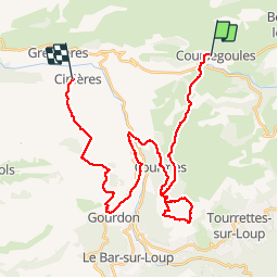
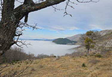
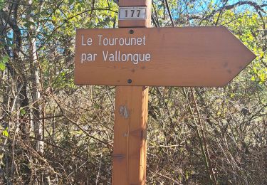
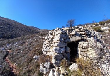
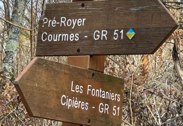
Trail Running of 36 km to be discovered at Provence-Alpes-Côte d'Azur, Maritime Alps, Coursegoules. This trail is proposed by guess.

Description

Reco du trail Esclapa l'Oeil 2016. Manque le 1er relais de Cipières à Coursegoules, comptez 4H en reco avec 1350 D

Elevation profile

Positioning

Country:
France
Region :
Provence-Alpes-Côte d'Azur
Department/Province :
Maritime Alps
Municipality :
Coursegoules
Location:
Unknown
Start:(UTM)
342369 ; 4850793 (32T) N.

Comments

Please log in to post a review or rate the element


Trails nearby

Trail On foot Coursegoules - Circuit du Viériou - Photo
On foot
PRO

On foot

Easy
Coursegoules, Provence-Alpes-Côte d'Azur, Maritime Alps, France
7.5 km | 13.1 km-effort
2h 58min
Yes
Trail On foot Gréolières - Traversée des Miroirs - Photo
On foot
PRO

On foot

Easy
Gréolières, Provence-Alpes-Côte d'Azur, Maritime Alps, France
6.6 km | 12 km-effort
2h 43min
No
Trail On foot Vence - Plan des Noves - Photo
On foot
PRO

On foot

Easy
Vence, Provence-Alpes-Côte d'Azur, Maritime Alps, France
7.2 km | 10.3 km-effort
2h 20min
Yes
Trail Walking Coursegoules - Coursegoule, Sommets Vierou et Prêt  - Photo
Walking
GrouGary

Walking

Very easy
Coursegoules, Provence-Alpes-Côte d'Azur, Maritime Alps, France
12.2 km | 19.5 km-effort
5h 53min
Yes
Trail Walking Vence - Col de Vence - Village des Idôles - Puy de Tourettes - Pic des Courmettes - Tourettes sur Loup - Photo
Walking
LtZIP

Walking

Medium
Vence, Provence-Alpes-Côte d'Azur, Maritime Alps, France
19.1 km | 28 km-effort
4h 23min
No
Trail Walking Coursegoules - Circuit de Vallon - Photo
Walking
56jj

Walking

Medium
(1)
Coursegoules, Provence-Alpes-Côte d'Azur, Maritime Alps, France
10.5 km | 14.8 km-effort
3h 29min
Yes
Trail Walking Courmes - Bramafan - Photo
Walking
Renefrt

Walking

Very easy
Courmes, Provence-Alpes-Côte d'Azur, Maritime Alps, France
11.6 km | 0 m-effort
5h 57min
Yes
Trail Walking Coursegoules - Puy de Naouri  - Photo
Walking
Jean-François Thibaud

Walking

Easy
Coursegoules, Provence-Alpes-Côte d'Azur, Maritime Alps, France
8.2 km | 11.3 km-effort
3h 32min
Yes
Trail Walking Courmes - Courmes  - Photo
Walking
ETMU5496

Walking

Difficult
Courmes, Provence-Alpes-Côte d'Azur, Maritime Alps, France
24 km | 42 km-effort
6h 14min
Yes


Close
My subscriptions