Trail Other activity Fellering - Fellering- Ventron - Photo

Fellering- Ventron

 markrei
markrei

User

© OpenStreetMap contributors
Length
Length
30 km
Max alt
Max alt
1221 m
Uphill gradient
Uphill gradient
1707 m
Km-Effort
Km-Effort  
52 km
Min alt
Min alt
438 m
Downhill gradient
Downhill gradient
1670 m
Boucle
Boucle
No
Creation date :
2016-06-26 00:00:00.0
Updated on :
2016-06-26 00:00:00.0

(0 Reviews)

Other activity
Other activity
10h00
Difficulty : Medium

Scan this QR Code to open this trail in the SityTrail application

FREE GPS app for hiking

Logo SityTrail SityTrail

IGN / Geographical institutes

Download SityTrail from the App Store Download SityTrail from Google Play

Logo SityTrail SityTrail World

The world is yours!

Download SityTrail from the App Store Download SityTrail from Google Play Download SityTrail on Huawei AppGallery

About

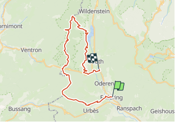
Trail Other activity of 30 km to be discovered at Grand Est, Haut-Rhin, Fellering. This trail is proposed by markrei.

Description

Fellering gare- Le Drumont - tete de Fellering - Col d'Oderen - Haut de Felsach - Petit Ventron - Le Grand ventron - Auberge du Grand ventron - Bocklochkopf - Lac de Kruth Wildenstein - Bourbach - Frenz - Kruth Gare
Guide : Pierre Jung

Elevation profile

Positioning

Country:
France
Region :
Grand Est
Department/Province :
Haut-Rhin
Municipality :
Fellering
Location:
Unknown
Start:(UTM)
349580 ; 5306859 (32T) N.

Trails nearby

Trail Walking Linthal - Markstein - Photo
Walking
VacheKiri67

Walking

Medium
(1)
Linthal, Grand Est, Haut-Rhin, France
14 km | 19.8 km-effort
4h 45min
Yes
Trail Walking Fellering - Felsach _chapelle ST Nicolas_frenz - Photo
Walking
Le grand Claude

Walking

Difficult
(1)
Fellering, Grand Est, Haut-Rhin, France
9.6 km | 16.5 km-effort
3h 45min
Yes
Trail On foot Lautenbachzell - Parking Bellevue - Hundsrucken - Markstein - Photo
On foot
patrickbeyrath

On foot

Medium
(1)
Lautenbachzell, Grand Est, Haut-Rhin, France
9.4 km | 13 km-effort
Unknown
Yes
Trail Walking Oderen - 6146369-Chapelle St Nicolas 2 - Photo
Walking

Walking

Medium
(1)
Oderen, Grand Est, Haut-Rhin, France
10.9 km | 17.9 km-effort
3h 41min
Yes
Trail Walking Oderen - trek alsacien (1ère étape) - Photo
Walking
Godasses et Grosses Pattes

Walking

Medium
Oderen, Grand Est, Haut-Rhin, France
9.2 km | 18.1 km-effort
4h 0min
No
Trail Walking Ranspach - Rando des Marcheurs 20/07/2023 - Photo
Walking
boubou68

Walking

Very difficult
Ranspach, Grand Est, Haut-Rhin, France
23 km | 38 km-effort
5h 31min
Yes
Trail Walking Storckensohn - Storckensohn Gazon Vert - Photo
Walking
helmut68

Walking

Difficult
Storckensohn, Grand Est, Haut-Rhin, France
13 km | 21 km-effort
4h 40min
Yes
Trail Walking Saint-Amarin - dimanche - Photo
Walking
Ninie38MD

Walking

Very difficult
(1)
Saint-Amarin, Grand Est, Haut-Rhin, France
19.4 km | 35 km-effort
7h 51min
Yes
Trail Walking Moosch - Moosch Haag - Photo
Walking
Estelle Handschin

Walking

Difficult
(1)
Moosch, Grand Est, Haut-Rhin, France
21 km | 0 m-effort
5h 27min
Yes


Close
My subscriptions