Trail Walking Vaals - Water Trek - Le Parcours des Sommets - Etape 1 : Plombières-Eupen - Photo

Water Trek - Le Parcours des Sommets - Etape 1 : Plombières-Eupen

Randonnées d'Aqualis PRO

© OpenStreetMap contributors
Length
Length
29 km
Max alt
Max alt
391 m
Uphill gradient
Uphill gradient
488 m
Km-Effort
Km-Effort  
35 km
Min alt
Min alt
162 m
Downhill gradient
Downhill gradient
512 m
Boucle
Boucle
No
Signpost
Signpost
Creation date :
2018-04-09 13:01:36.041
Updated on :
2018-04-09 13:01:36.041

(0 Reviews)

Walking
Walking
7h25
Difficulty : Medium

Scan this QR Code to open this trail in the SityTrail application

FREE GPS app for hiking

Logo SityTrail SityTrail

IGN / Geographical institutes

Download SityTrail from the App Store Download SityTrail from Google Play

Logo SityTrail SityTrail World

The world is yours!

Download SityTrail from the App Store Download SityTrail from Google Play Download SityTrail on Huawei AppGallery

About

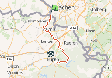
Trail Walking of 29 km to be discovered at Limburg, Unknown, Vaals. This trail is proposed by Aqualis.

Description

Le parcours est essentiellement tracé sur sentiers et chemins.
Trois tronçons empruntent des prairies et nécessitent le franchissement d’échaliers.Le paysage est marqué au départ par les vergers de l’est du Pays de Herve et ensuite par la forêt du massif de l’Hertogenwald. Après avoir suivi le cours de la Gueule, vous surplomberez le lac et le barrage d’Eupen.

Elevation profile

Photos

Points of interest

Point of interest Aachen - Les Trois Frontières - Photo
Aqualis
Point of interest Plombières - Zone de Pic Nic - Photo
Aqualis
PLOMBIÈRES 
Point of interest Plombières - Viaduc de Moresnet-Village - Photo
Aqualis
Point of interest Kelmis - Zone de Pic Nic - Photo
Aqualis
Point of interest Kelmis - Château d'Eyneburg - Photo
Aqualis
Point of interest Lontzen - Château de Thor - Photo
Aqualis
Point of interest Eupen - Barrage de la Vesdre - Photo
Aqualis
Point of interest Eupen - Gîte d'Etape - Photo
Aqualis

Positioning

Country:
Netherlands
Region :
Limburg
Department/Province :
Unknown
Municipality :
Vaals
Location:
Unknown
Start:(UTM)
289882 ; 5626734 (32U) N.

Trails nearby

Trail Walking Kelmis - Le pays calaminaire - Photo
Walking
GUIDE
mumu.larandonneuse

Walking

Medium
(1)
Kelmis, Wallonia, Liège, Belgium
9.6 km | 12.1 km-effort
2h 44min
Yes
Trail Walking Raeren - 2023-09-21_15h54m11_392.gpx.xml - Photo
Walking
GUIDE
mumu.larandonneuse

Walking

Medium
(1)
Raeren, Wallonia, Liège, Belgium
13.2 km | 17.3 km-effort
3h 55min
Yes
Trail Walking Vaals - 2023-04-07_19h11m12_788 - Photo
Walking
GUIDE
mumu.larandonneuse

Walking

Medium
(1)
Vaals, Limburg, Unknown, Netherlands
12.9 km | 16.3 km-effort
3h 42min
Yes
Trail Walking Vaals - 2023-04-07_19h07m33_235 - Photo
Walking
GUIDE
mumu.larandonneuse

Walking

Medium
(1)
Vaals, Limburg, Unknown, Netherlands
14.7 km | 18.3 km-effort
4h 9min
Yes
Trail Walking Kelmis - La Calamine - Photo
Walking
GUIDE
mumu.larandonneuse

Walking

Easy
(1)
Kelmis, Wallonia, Liège, Belgium
9.1 km | 11.6 km-effort
2h 38min
Yes
Trail Walking Aachen - Aix-la-Chapelle  - Photo
Walking
GUIDE
mumu.larandonneuse

Walking

Easy
(1)
Aachen, North Rhine-Westphalia, Städteregion Aachen, Germany
11.4 km | 15.4 km-effort
3h 30min
Yes
Trail Walking Aachen - Aix-la-Chapelle  - Photo
Walking
GUIDE
mumu.larandonneuse

Walking

Easy
(1)
Aachen, North Rhine-Westphalia, Städteregion Aachen, Germany
11.1 km | 13.4 km-effort
3h 2min
Yes
Trail Walking Vaals - 2022-11-11_17h47m43_wandelroute---cittaslow-rondje-viele - Photo
Walking
GUIDE
mumu.larandonneuse

Walking

Medium
(1)
Vaals, Limburg, Unknown, Netherlands
12.8 km | 17.1 km-effort
3h 53min
Yes
Trail Walking Kelmis - 2022-01-18_14h17m25_kelmis - Photo
Walking
GUIDE
mumu.larandonneuse

Walking

Easy
(1)
Kelmis, Wallonia, Liège, Belgium
14.2 km | 18.4 km-effort
4h 10min
Yes


Close
My subscriptions