Trail Mountain bike Hohrod - stosswihr hohrodberg cimetière allemand  - Photo

stosswihr hohrodberg cimetière allemand

 sit68000
sit68000

User

© OpenStreetMap contributors
Length
Length
16.1 km
Max alt
Max alt
941 m
Uphill gradient
Uphill gradient
598 m
Km-Effort
Km-Effort  
24 km
Min alt
Min alt
409 m
Downhill gradient
Downhill gradient
595 m
Boucle
Boucle
Yes
Creation date :
2016-06-30 00:00:00.0
Updated on :
2016-06-30 00:00:00.0

(0 Reviews)

Mountain bike
Mountain bike
2h38
Difficulty : Difficult

Scan this QR Code to open this trail in the SityTrail application

FREE GPS app for hiking

Logo SityTrail SityTrail

IGN / Geographical institutes

Download SityTrail from the App Store Download SityTrail from Google Play

Logo SityTrail SityTrail World

The world is yours!

Download SityTrail from the App Store Download SityTrail from Google Play Download SityTrail on Huawei AppGallery

About

Trail Mountain bike of 16.1 km to be discovered at Grand Est, Haut-Rhin, Hohrod. This trail is proposed by sit68000.

Description

beau circuit avec beaucoup de sentiers

Elevation profile

Photos

Positioning

Country:
France
Region :
Grand Est
Department/Province :
Haut-Rhin
Municipality :
Hohrod
Location:
Unknown
Start:(Dec)
Start:(UTM)
359896 ; 5323477 (32U) N.

Trails nearby

Trail Other activity Soultzeren - Totom 4 lacs - Photo
Other activity
dinozore

Other activity

Medium
(1)
Soultzeren, Grand Est, Haut-Rhin, France
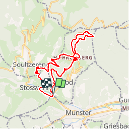
15.6 km | 26 km-effort
4h 37min
Yes
Trail Walking Munster - De Munster aux 3 Fours (Aller) - Munster - Photo
Walking
tracegps

Walking

Difficult
(1)
Munster, Grand Est, Haut-Rhin, France
14.8 km | 27 km-effort
5h 0min
No
Trail Walking Hohrod - Circuit historique 1914-18 Hohrodberg - Linge - Photo
Walking
VacheKiri67

Walking

Medium
(1)
Hohrod, Grand Est, Haut-Rhin, France
14 km | 19.8 km-effort
5h 50min
Yes
Trail Walking Munster - 19.06.13.Munster  - Photo
Walking
ROPPJP

Walking

Very easy
(1)
Munster, Grand Est, Haut-Rhin, France
7.3 km | 10.6 km-effort
2h 10min
Yes
Trail Walking Soultzeren - Tanet-Gazon du faing par lac vert et retour sommet du Tanet - Photo
Walking
ride-in-Elsass

Walking

Medium
(1)
Soultzeren, Grand Est, Haut-Rhin, France
10 km | 15.6 km-effort
4h 24min
Yes
Trail Mountain bike Metzeral - Sentier des Névés - Photo
Mountain bike
tracegps

Mountain bike

Very difficult
(1)
Metzeral, Grand Est, Haut-Rhin, France
33 km | 52 km-effort
6h 0min
Yes
Trail Horseback riding Gunsbach - Le petit Hohnack - verkort (23) - Photo
Horseback riding
eddyvermeulen1

Horseback riding

Easy
(1)
Gunsbach, Grand Est, Haut-Rhin, France
13.1 km | 18.4 km-effort
2h 25min
Yes
Trail Walking Soultzeren - 2022-12-27 Marche Soultzeren Lac Forlet Hautes Huttes Glasborn - Photo
Walking
GUIDE
holtzv

Walking

Very difficult
Soultzeren, Grand Est, Haut-Rhin, France
21 km | 34 km-effort
5h 47min
Yes
Trail Horseback riding Stosswihr - 2018-08-26 Picnic CVA Cascades Stosswihr - Photo
Horseback riding
GUIDE
holtzv

Horseback riding

Easy
Stosswihr, Grand Est, Haut-Rhin, France
19.2 km | 29 km-effort
3min
Yes


Close
My subscriptions