Trail Mountain bike Theux - MENOBU - LA FAGNE plus court - Photo

MENOBU - LA FAGNE plus court

© OpenStreetMap contributors
Length
Length
21 km
Max alt
Max alt
438 m
Uphill gradient
Uphill gradient
499 m
Km-Effort
Km-Effort  
27 km
Min alt
Min alt
200 m
Downhill gradient
Downhill gradient
495 m
Boucle
Boucle
Yes
Creation date :
2016-09-15 00:00:00.0
Updated on :
2016-09-15 00:00:00.0

(1 Reviews)

Mountain bike
Mountain bike
1h45
Difficulty : Medium

Scan this QR Code to open this trail in the SityTrail application

FREE GPS app for hiking

Logo SityTrail SityTrail

IGN / Geographical institutes

Download SityTrail from the App Store Download SityTrail from Google Play

Logo SityTrail SityTrail World

The world is yours!

Download SityTrail from the App Store Download SityTrail from Google Play Download SityTrail on Huawei AppGallery

About

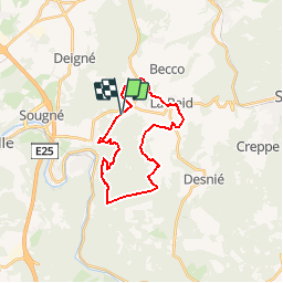
Trail Mountain bike of 21 km to be discovered at Wallonia, Liège, Theux. This trail is proposed by NanardPet.

Description

Cortil VTT : Ce parcours débute sur les hauteurs de Remouchamps, Chemin de Nonceveux la ou était installé le ravito N°3 de la Bataille des Ardennes 2016. Le circuit démarre en douceur vers La Reid et quelques chemins de L'Ardenne Trophy pour ensuite filler vers Ville au Bois et rouler sur des sentiers fagnards. Il croise la Vequée avant de débouler sur Le Montouet puis La Chapelle de Targnon et rejoindre les rives de la Lienne. Montée très physique vers l'ancienne école de Chèssion. Single track très ludique pour redescendre sur l'Amblève à hauteur de l'ancienne Maison Thonnard. Le parcours suit la rivière en surplomb avant une très longue côte en direction de Chevron pour redescendre jusqu'au pont en bois du château De Spirlet. L'itinéraire emprunte un petit sentier le long de l'Amblève jusque Quarreux pour gravir l'autre flanc de colline vers le point de vue Drouet. à ce moment débute un single track en descente très technique qui nécessite un portage en descente de  -150m. Décors magnifique et frissons garantis. Une fois en bas il reste un gué et la remontée vers le lieux de départ. Au total: 43km et  1180m d'un parcours assez physique. Deux points de ravitos et pas de vélocistes.

Elevation profile

Points of interest

Point of interest Theux - 10.23 km - Photo
NanardPet
THEUX 
Point of interest Theux - 11.6 km - Photo
NanardPet
THEUX 
Point of interest Aywaille - Point de variante - Photo
NanardPet

Positioning

Country:
Belgium
Region :
Wallonia
Department/Province :
Liège
Municipality :
Theux
Location:
La Reid
Start:(UTM)
695760 ; 5596140 (31U) N.

Comments

Please log in to post a review or rate the element


parfait


Trails nearby

Trail Walking Theux - RB-Lg-24_La-Reid_via-racc-1 - Photo
Walking
PRO

Walking

Difficult
(9)
Theux, Wallonia, Liège, Belgium
14.9 km | 20 km-effort
4h 16min
Yes
Trail Walking Theux - RB-Lg-24_La-Reid - Photo
Walking
PRO

Walking

Very difficult
(8)
Theux, Wallonia, Liège, Belgium
21 km | 28 km-effort
6h 21min
Yes
Trail Walking Aywaille - RB-Lg-12 - De Sougné-Remouchamps à Deigné et retour - Photo
Walking
PRO

Walking

Difficult
(9)
Aywaille, Wallonia, Liège, Belgium
24 km | 34 km-effort
7h 39min
Yes
Trail Walking Aywaille - Petite remontée du Ninglispo - Photo
Walking
henriantoine

Walking

Medium
(9)
Aywaille, Wallonia, Liège, Belgium
6.7 km | 9.7 km-effort
2h 11min
Yes
Trail Walking Aywaille - RB-LG-12 - Raccourci 2 - Photo
Walking
PRO

Walking

Difficult
(5)
Aywaille, Wallonia, Liège, Belgium
17 km | 25 km-effort
5h 46min
Yes
Trail Walking Theux - RF-Lg-08_Franchimont_Grande-boucle - Photo
Walking
PRO

Walking

Very easy
(6)
Theux, Wallonia, Liège, Belgium
10.8 km | 14.6 km-effort
3h 9min
Yes
Trail Walking Theux - 20220717 - HUWAO La Reid - 7 Km - Photo
Walking
GUIDE
pierreh01

Walking

Medium
(2)
Theux, Wallonia, Liège, Belgium
7 km | 9.5 km-effort
2h 34min
Yes
Trail Walking Aywaille - 2021-02-21_16h28m36_1382 - Photo
Walking
GUIDE
mumu.larandonneuse

Walking

Medium
(1)
Aywaille, Wallonia, Liège, Belgium
15.7 km | 22 km-effort
4h 53min
Yes
Trail Walking Aywaille - RB-Lg-12 - Raccourci 1 - Photo
Walking
PRO

Walking

Difficult
(1)
Aywaille, Wallonia, Liège, Belgium
21 km | 31 km-effort
6h 42min
Yes


Close
My subscriptions