Trail Walking Aspres-lès-Corps - Aspres les corps - Roche Courbe - Photo
 R@ph
R@ph

User GUIDE

© OpenStreetMap contributors
Length
Length
10.6 km
Max alt
Max alt
1920 m
Uphill gradient
Uphill gradient
1000 m
Km-Effort
Km-Effort  
24 km
Min alt
Min alt
966 m
Downhill gradient
Downhill gradient
1003 m
Boucle
Boucle
Yes
Creation date :
2016-11-03 00:00:00.0
Updated on :
2016-11-03 00:00:00.0

(1 Reviews)

Walking
Walking
4h53
Difficulty : Very difficult

Scan this QR Code to open this trail in the SityTrail application

FREE GPS app for hiking

Logo SityTrail SityTrail

IGN / Geographical institutes

Download SityTrail from the App Store Download SityTrail from Google Play

Logo SityTrail SityTrail World

The world is yours!

Download SityTrail from the App Store Download SityTrail from Google Play Download SityTrail on Huawei AppGallery

About

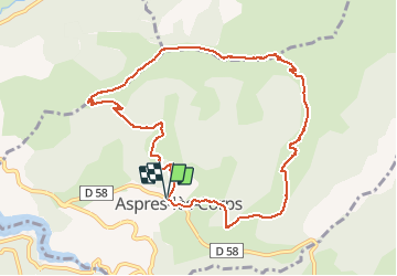
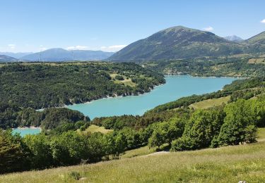
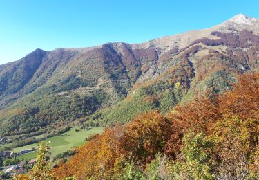
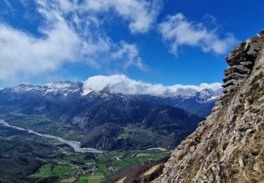
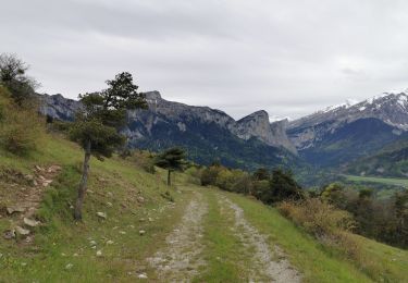
Trail Walking of 10.6 km to be discovered at Provence-Alpes-Côte d'Azur, Hautes-Alpes, Aspres-lès-Corps. This trail is proposed by R@ph.

Elevation profile

Photos

Points of interest

Point of interest La Salette-Fallavaux - Roche Courbe - Photo
R@ph
LA SALETTE-FALLAVAUX 
Point of interest Aspres-lès-Corps - Lac du Sautet - Photo
R@ph
ASPRES-LÈS-CORPS 

Positioning

Country:
France
Region :
Provence-Alpes-Côte d'Azur
Department/Province :
Hautes-Alpes
Municipality :
Aspres-lès-Corps
Location:
Unknown
Start:(UTM)
735664 ; 4965318 (31T) N.

Comments

Please log in to post a review or rate the element


Merci


Trails nearby

Trail Walking Saint-Jacques-en-Valgodemard - Tour du Vieux Chaillol 1/5 - Gite Les Paris au Gite Le Casset - Photo
Walking
tracegps

Walking

Medium
(1)
Saint-Jacques-en-Valgodemard, Provence-Alpes-Côte d'Azur, Hautes-Alpes, France
20 km | 27 km-effort
6h 30min
No
Trail Walking Saint-Firmin - YHH081 Vallon de Prentiq - Photo
Walking
yveshumbert

Walking

Very easy
(1)
Saint-Firmin, Provence-Alpes-Côte d'Azur, Hautes-Alpes, France
6.7 km | 11.1 km-effort
2h 30min
Yes
Trail Walking Monestier-d'Ambel - croix de la plaigni - Photo
Walking
bailleulherve

Walking

Easy
Monestier-d'Ambel, Auvergne-Rhône-Alpes, Isère, France
13.2 km | 25 km-effort
4h 2min
No
Trail Touring skiing La Salette-Fallavaux - Pale ronde et col de près clos - Photo
Touring skiing
nadd73

Touring skiing

Easy
La Salette-Fallavaux, Auvergne-Rhône-Alpes, Isère, France
10.1 km | 25 km-effort
6h 16min
Yes
Trail Touring skiing Aspres-lès-Corps - tentative du Laton, pic gazonné  - Photo
Touring skiing
nadd73

Touring skiing

Easy
Aspres-lès-Corps, Provence-Alpes-Côte d'Azur, Hautes-Alpes, France
6.9 km | 15.9 km-effort
4h 36min
Yes
Trail Walking Aspres-lès-Corps - Roche Courbe en circuit - Photo
Walking
Emelle

Walking

Medium
Aspres-lès-Corps, Provence-Alpes-Côte d'Azur, Hautes-Alpes, France
9.9 km | 23 km-effort
5h 57min
Yes
Trail Walking Saint-Firmin - Les pres hauts  6 kms - Photo
Walking
peillo

Walking

Saint-Firmin, Provence-Alpes-Côte d'Azur, Hautes-Alpes, France
5.2 km | 9.6 km-effort
1h 55min
Yes
Trail Walking Aspres-lès-Corps - Le Grand Journal - Jonquilles  - Photo
Walking
PapouBertrand

Walking

Very difficult
Aspres-lès-Corps, Provence-Alpes-Côte d'Azur, Hautes-Alpes, France
9.6 km | 22 km-effort
5h 19min
Yes
Trail Walking Ambel - 20210518_Ambel - Tête de la Sambut  - Photo
Walking
PapouBertrand

Walking

Difficult
Ambel, Auvergne-Rhône-Alpes, Isère, France
13.4 km | 24 km-effort
5h 15min
Yes


Close
My subscriptions