Trail Walking Mézières-sur-Couesnon - 3eme etape LA SECARDAIS - ROMAZY - Photo

3eme etape LA SECARDAIS - ROMAZY

© OpenStreetMap contributors
Length
Length
19 km
Max alt
Max alt
106 m
Uphill gradient
Uphill gradient
246 m
Km-Effort
Km-Effort  
22 km
Min alt
Min alt
44 m
Downhill gradient
Downhill gradient
269 m
Boucle
Boucle
No
Creation date :
2016-12-03 00:00:00.0
Updated on :
2016-12-03 00:00:00.0

(0 Reviews)

Walking
Walking
5h24
Difficulty : Medium

Scan this QR Code to open this trail in the SityTrail application

FREE GPS app for hiking

Logo SityTrail SityTrail

IGN / Geographical institutes

Download SityTrail from the App Store Download SityTrail from Google Play

Logo SityTrail SityTrail World

The world is yours!

Download SityTrail from the App Store Download SityTrail from Google Play Download SityTrail on Huawei AppGallery

About

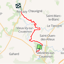
Trail Walking of 19 km to be discovered at Brittany, Ille-et-Vilaine, Mézières-sur-Couesnon. This trail is proposed by MoulinPierrick.

Description

Sentier roman Rennes - Mont Saint Michel

Elevation profile

Points of interest

Point of interest Mézières-sur-Couesnon - Point 1 - Photo
MoulinPierrick
MÉZIÈRES-SUR-COUESNON 
Point of interest Saint-Christophe-de-Valains - Point 2 - Photo
MoulinPierrick
SAINT-CHRISTOPHE-DE-VALAINS 
Point of interest Saint-Christophe-de-Valains - Point 3 - Photo
MoulinPierrick
SAINT-CHRISTOPHE-DE-VALAINS 

Positioning

Country:
France
Region :
Brittany
Department/Province :
Ille-et-Vilaine
Municipality :
Mézières-sur-Couesnon
Location:
Unknown
Start:(UTM)
614345 ; 5350841 (30U) N.

Trails nearby

Trail On foot Saint-Aubin-du-Cormier - Roche Piquée - Photo
On foot
PRO

On foot

Easy
Saint-Aubin-du-Cormier, Brittany, Ille-et-Vilaine, France
5.3 km | 6.2 km-effort
1h 24min
Yes
Trail On foot Saint-Aubin-du-Cormier - La lande de la rencontre - Photo
On foot
PRO

On foot

Easy
Saint-Aubin-du-Cormier, Brittany, Ille-et-Vilaine, France
8.2 km | 9.5 km-effort
2h 9min
Yes
Trail On foot Saint-Ouen-des-Alleux - Le Pays Audonien - Photo
On foot
PRO

On foot

Easy
Saint-Ouen-des-Alleux, Brittany, Ille-et-Vilaine, France
12 km | 13.7 km-effort
3h 6min
Yes
Trail Walking Saint-Aubin-du-Cormier - GR_37_BC_30_St-Aubin-Cormier_Erce-Pres-Liffre_20211211 - Photo
Walking
patrickdanilo

Walking

Easy
Saint-Aubin-du-Cormier, Brittany, Ille-et-Vilaine, France
16.4 km | 19.2 km-effort
4h 54min
No
Trail Walking Saint-Ouen-des-Alleux - Le couesnon - Photo
Walking
phverly

Walking

Easy
(1)
Saint-Ouen-des-Alleux, Brittany, Ille-et-Vilaine, France
7.3 km | 9.1 km-effort
2h 0min
Yes
Trail Equestrian Mézières-sur-Couesnon - Au fil de l'eau - Mézières sur Couesnon - Photo
Equestrian
tracegps

Equestrian

Very difficult
Mézières-sur-Couesnon, Brittany, Ille-et-Vilaine, France
71 km | 83 km-effort
8h 0min
No
Trail Walking Saint-Christophe-de-Valains - Sur le sentier des Picaous -  Saint Christophe de Valains - Photo
Walking
tracegps

Walking

Easy
Saint-Christophe-de-Valains, Brittany, Ille-et-Vilaine, France
4.9 km | 5.6 km-effort
1h 15min
Yes
Trail Walking Saint-Aubin-du-Cormier - 11.01.2018 - ST AUBIN DU CORMIER  - Photo
Walking
babeth35

Walking

Medium
Saint-Aubin-du-Cormier, Brittany, Ille-et-Vilaine, France
24 km | 27 km-effort
8h 13min
No
Trail Walking Saint-Aubin-du-Cormier - 27/12/2017 - ST AUBIN DU CORMIER d'est en ouest.Virtuel - Photo
Walking
babeth35

Walking

Medium
Saint-Aubin-du-Cormier, Brittany, Ille-et-Vilaine, France
29 km | 34 km-effort
7h 14min
Yes


Close
My subscriptions