


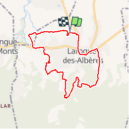
RP66 LAROQUE Boucle le 01.02.2017

jeff66
User


1h27
Difficulty : Medium

FREE GPS app for hiking
 SityTrail
IGN / Geographical institutes
SityTrail Plus
The world is yours!
About
Trail Walking of 8.5 km to be discovered at Occitania, Pyrénées-Orientales, Laroque-des-Albères. This trail is proposed by jeff66.
Description
RP66 LAROQUE Boucle le 01.02.2017 - Les Vernèdes - Mas Rancoure - Les Olivedes - Mas Py - saint fructueux de ROCA VELLA - canal - réservoir - Mas d'en Bordes, d'en Malzac,
D'en Blanc, Sors et Manère - chemin de la montagne - centre ville
Positioning
Comments