Trail Snowshoes Ancizan - RQ-Payolle-Plo-Del-Naou - Photo

RQ-Payolle-Plo-Del-Naou

 Polo-31
Polo-31

User

© OpenStreetMap contributors
Length
Length
11.1 km
Max alt
Max alt
1749 m
Uphill gradient
Uphill gradient
669 m
Km-Effort
Km-Effort  
20 km
Min alt
Min alt
1088 m
Downhill gradient
Downhill gradient
669 m
Boucle
Boucle
Yes
Creation date :
2017-03-24 00:00:00.0
Updated on :
2017-03-24 00:00:00.0

(0 Reviews)

Snowshoes
Snowshoes
5h00
Difficulty : Medium

Scan this QR Code to open this trail in the SityTrail application

FREE GPS app for hiking

Logo SityTrail SityTrail

IGN / Geographical institutes

Download SityTrail from the App Store Download SityTrail from Google Play

Logo SityTrail SityTrail World

The world is yours!

Download SityTrail from the App Store Download SityTrail from Google Play Download SityTrail on Huawei AppGallery

About

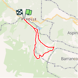
Trail Snowshoes of 11.1 km to be discovered at Occitania, Hautespyrenees, Ancizan. This trail is proposed by Polo-31.

Description

Départ depuis le lac de Payolle. Montée dans le bois de Differend par Sarraoute pour atteindre le Plo del Naou à 1754m. Descente vers les cabanes de La Hosse où la plus ancienne reste ouverte l'hiver (pratique pour le pique-nique). Retour au lac de Payolle à travers la hêtraie et en suivant une piste de ski de fond vers la fin. Randonnée raquettes exigeante, car 1m à 1,20 m de neige fraîche dans laquelle il a fallu faire la trace. Mais en haut superbe paysage sur les sommets et sur la vallée d'Aure.

Elevation profile

Positioning

Country:
France
Region :
Occitania
Department/Province :
Hautespyrenees
Municipality :
Ancizan
Location:
Unknown
Start:(UTM)
278110 ; 4758020 (31T) N.

Trails nearby

Trail Walking Esparros - Du Signal de Bassia vers le col de Beyrède par la crête sud-est et le Pas de Bassia - Photo
Walking
2034

Walking

Medium
(9)
Esparros, Occitania, Hautespyrenees, France
3.2 km | 5.1 km-effort
48min
No
Trail Walking Ancizan - Lac d'Arou - Payolle - Photo
Walking
tracegps

Walking

Medium
(4)
Ancizan, Occitania, Hautespyrenees, France
9.8 km | 14.9 km-effort
3h 30min
Yes
Trail Walking Beyrède-Jumet-Camous - Signal de Bassia de Hèche - Photo
Walking
tracegps

Walking

Very difficult
(1)
Beyrède-Jumet-Camous, Occitania, Hautespyrenees, France
3.1 km | 8.2 km-effort
3h 30min
No
Trail On foot Campan - Boucle d'Espiadet - Photo
On foot
PRO

On foot

Easy
Campan, Occitania, Hautespyrenees, France
4.2 km | 6.3 km-effort
1h 25min
No
Trail Walking Ancizan - Soum de Coste Oueillère - Photo
Walking
GUIDE
lhomme.ph

Walking

Difficult
(1)
Ancizan, Occitania, Hautespyrenees, France
9.6 km | 23 km-effort
4h 26min
Yes
Trail Walking Beyrède-Jumet-Camous - Le signal de Bassia depuis le col de Beyrède - Photo
Walking
2033

Walking

Medium
(3)
Beyrède-Jumet-Camous, Occitania, Hautespyrenees, France
4.1 km | 10.3 km-effort
1h 53min
Yes
Trail Walking Campan - Pic de  Bassia, Pic du Castillon, Pic de Paou - Photo
Walking
Prala

Walking

Very easy
(1)
Campan, Occitania, Hautespyrenees, France
10.3 km | 22 km-effort
3h 52min
No
Trail Snowshoes Campan - raquet 1 - Photo
Snowshoes
eliott3

Snowshoes

Easy
(1)
Campan, Occitania, Hautespyrenees, France
4.9 km | 7.2 km-effort
2h 10min
Yes
Trail Walking Campan - payolle - Photo
Walking
yfouldrin

Walking

Very easy
(1)
Campan, Occitania, Hautespyrenees, France
6.5 km | 8.2 km-effort
1h 52min
Yes


Close
My subscriptions