Trail Running Rio Mau - SERRA DAS BANJAS - Photo

SERRA DAS BANJAS

 sim1491
sim1491

User

© OpenStreetMap contributors
Length
Length
16.2 km
Max alt
Max alt
335 m
Uphill gradient
Uphill gradient
576 m
Km-Effort
Km-Effort  
24 km
Min alt
Min alt
14 m
Downhill gradient
Downhill gradient
575 m
Boucle
Boucle
Yes
Creation date :
2017-03-21 00:00:00.0
Updated on :
2017-03-21 00:00:00.0

(0 Reviews)

Running
Running
2h00
Difficulty : Medium

Scan this QR Code to open this trail in the SityTrail application

FREE GPS app for hiking

Logo SityTrail SityTrail

IGN / Geographical institutes

Download SityTrail from the App Store Download SityTrail from Google Play

Logo SityTrail SityTrail World

The world is yours!

Download SityTrail from the App Store Download SityTrail from Google Play Download SityTrail on Huawei AppGallery

About

Trail Running of 16.2 km to be discovered at North, Porto, Rio Mau. This trail is proposed by sim1491.

Elevation profile

Positioning

Country:
Portugal
Region :
North
Department/Province :
Porto
Municipality :
Rio Mau
Location:
Unknown
Start:(UTM)
553004 ; 4544917 (29T) N.

Trails nearby

Trail Walking Rio Mau - Porto 7 - Photo
Walking
francineposkin

Walking

Medium
Rio Mau, North, Porto, Portugal
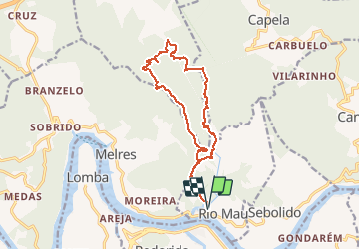
6.8 km | 10.1 km-effort
2h 16min
Yes
Trail Running Rio Mau - FRAGAS DA ABITOREIRA (RIO MAU) - Photo
Running
sim1491

Running

Medium
Rio Mau, North, Porto, Portugal
11.4 km | 17.3 km-effort
2h 0min
Yes


Close
My subscriptions