Trail Walking Écrouves - Ecrouves 11300m 270m+ - Photo
© OpenStreetMap contributors
Length
Length
11.1 km
Max alt
Max alt
380 m
Uphill gradient
Uphill gradient
246 m
Km-Effort
Km-Effort  
14.3 km
Min alt
Min alt
245 m
Downhill gradient
Downhill gradient
245 m
Boucle
Boucle
Yes
Creation date :
2017-04-02 00:00:00.0
Updated on :
2017-04-02 00:00:00.0

(0 Reviews)

Walking
Walking
3h10
Difficulty : Easy

Scan this QR Code to open this trail in the SityTrail application

FREE GPS app for hiking

Logo SityTrail SityTrail

IGN / Geographical institutes

Download SityTrail from the App Store Download SityTrail from Google Play

Logo SityTrail SityTrail World

The world is yours!

Download SityTrail from the App Store Download SityTrail from Google Play Download SityTrail on Huawei AppGallery

About

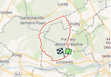
Trail Walking of 11.1 km to be discovered at Grand Est, Meurthe-et-Moselle, Écrouves. This trail is proposed by DanielROLLET.

Description

02.04.2016 rando ASPV 13p.
11300m 270m
9h05 à 11h55 soit 2h50mn
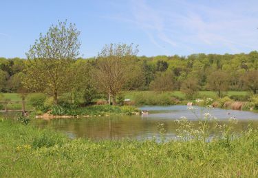
Grand beau temps. mirabelliers en fleurs.

Elevation profile

Positioning

Country:
France
Region :
Grand Est
Department/Province :
Meurthe-et-Moselle
Municipality :
Écrouves
Location:
Unknown
Start:(UTM)
709003 ; 5396023 (31U) N.

Trails nearby

Trail On foot Bruley - Circuit de la Petite Linotte - Photo
On foot
PRO

On foot

Easy
Bruley, Grand Est, Meurthe-et-Moselle, France
9.2 km | 12 km-effort
2h 43min
No
Trail Mountain bike Toul - Côtes de Toul 50k 2012 - Photo
Mountain bike
virginieHurpeau

Mountain bike

Difficult
(2)
Toul, Grand Est, Meurthe-et-Moselle, France
59 km | 75 km-effort
5h 15min
Yes
Trail Mountain bike Écrouves - 1 ère rando VTT - Photo
Mountain bike
ericsnoopy

Mountain bike

Very easy
(1)
Écrouves, Grand Est, Meurthe-et-Moselle, France
7.5 km | 9.5 km-effort
Unknown
Yes
Trail On foot Laneuveville-derrière-Foug - Circuit de Domfontaine - Photo
On foot
PRO

On foot

Easy
Laneuveville-derrière-Foug, Grand Est, Meurthe-et-Moselle, France
9.5 km | 12.6 km-effort
2h 51min
Yes
Trail On foot Trondes - Circuit du Romont - Photo
On foot
PRO

On foot

Easy
Trondes, Grand Est, Meurthe-et-Moselle, France
6.8 km | 8.1 km-effort
1h 50min
Yes
Trail On foot Foug - Circuit de Grammont - Photo
On foot
PRO

On foot

Easy
Foug, Grand Est, Meurthe-et-Moselle, France
15.6 km | 19.3 km-effort
4h 23min
No
Trail On foot Choloy-Ménillot - Boucle des Sources - Photo
On foot
PRO

On foot

Easy
Choloy-Ménillot, Grand Est, Meurthe-et-Moselle, France
10.4 km | 11.9 km-effort
2h 42min
No
Trail On foot Lucey - Circuit des Vignes - Photo
On foot
PRO

On foot

Easy
Lucey, Grand Est, Meurthe-et-Moselle, France
4.2 km | 5.2 km-effort
1h 11min
Yes
Trail On foot Laneuveville-derrière-Foug - Circuit du Point du Jour - Photo
On foot
PRO

On foot

Easy
Laneuveville-derrière-Foug, Grand Est, Meurthe-et-Moselle, France
6.8 km | 8 km-effort
1h 49min
No


Close
My subscriptions