Trail Walking Bagnols-en-Forêt - Bagnols en Forêt - GR51 new - Photo
 Sugg
Sugg

User

© OpenStreetMap contributors
Length
Length
16 km
Max alt
Max alt
418 m
Uphill gradient
Uphill gradient
465 m
Km-Effort
Km-Effort  
22 km
Min alt
Min alt
225 m
Downhill gradient
Downhill gradient
464 m
Boucle
Boucle
Yes
Creation date :
2019-03-22 16:58:27.747
Updated on :
2019-03-22 16:58:27.798

(0 Reviews)

Walking
Walking
5h00
Difficulty : Easy

Scan this QR Code to open this trail in the SityTrail application

FREE GPS app for hiking

Logo SityTrail SityTrail

IGN / Geographical institutes

Download SityTrail from the App Store Download SityTrail from Google Play

Logo SityTrail SityTrail World

The world is yours!

Download SityTrail from the App Store Download SityTrail from Google Play Download SityTrail on Huawei AppGallery

About

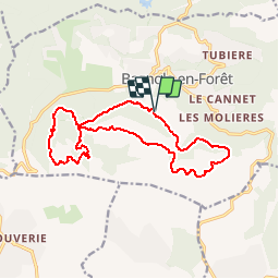
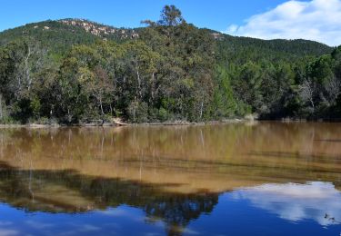
Trail Walking of 16 km to be discovered at Provence-Alpes-Côte d'Azur, Var, Bagnols-en-Forêt. This trail is proposed by Sugg.

Description

Circuit de remplacement du mercredi 3 mai 2017 sur des bases connues, mais à l'envers.
Départ cimetière,piste de petit Roc, GR51, contournement de " l'église des Païens " piste de bayonne et cimetière en 258.

Elevation profile

Positioning

Country:
France
Region :
Provence-Alpes-Côte d'Azur
Department/Province :
Var
Municipality :
Bagnols-en-Forêt
Location:
Unknown
Start:(UTM)
313442 ; 4822267 (32T) N.

Trails nearby

Trail Mountain bike Puget-sur-Argens - Forêt de la Colle du Rouet aux Gorges de Blavet - Fréjus - Photo
Mountain bike
tracegps

Mountain bike

Difficult
(1)
Puget-sur-Argens, Provence-Alpes-Côte d'Azur, Var, France
23 km | 28 km-effort
3h 0min
Yes
Trail Walking Bagnols-en-Forêt - La Colle du Rouet par le Castel Diaou - Le Muy - Photo
Walking
tracegps

Walking

Difficult
(2)
Bagnols-en-Forêt, Provence-Alpes-Côte d'Azur, Var, France
18.2 km | 27 km-effort
6h 0min
Yes
Trail Nordic walking Puget-sur-Argens - La Tranchée - Terre Gastes - Les Suviéres -   IBP 37 Bleu (241) - Photo
Nordic walking
ChicanneMaryse

Nordic walking

Easy
(1)
Puget-sur-Argens, Provence-Alpes-Côte d'Azur, Var, France
10.2 km | 11.6 km-effort
Unknown
Yes
Trail On foot Bagnols-en-Forêt - BAGNOLS EN FORET- Bois du défens DRI - Photo
On foot

On foot

Easy
(2)
Bagnols-en-Forêt, Provence-Alpes-Côte d'Azur, Var, France
9.3 km | 12.7 km-effort
2h 52min
Yes
Trail Walking Bagnols-en-Forêt - Gorges du Blavet au col de la pierre du coucou - Photo
Walking
GUIDE
nadinebondoux

Walking

Difficult
Bagnols-en-Forêt, Provence-Alpes-Côte d'Azur, Var, France
15.8 km | 22 km-effort
4h 44min
Yes
Trail On foot Roquebrune-sur-Argens - 2024-03-12_16h48m05_Randonn_e-44 - Photo
On foot
marsouin 83

On foot

Easy
(1)
Roquebrune-sur-Argens, Provence-Alpes-Côte d'Azur, Var, France
11.6 km | 16.2 km-effort
3h 41min
Yes
Trail Walking Roquebrune-sur-Argens - LA BOUVERIE / grottes /malvoisin/église des paiens/muerons - Photo
Walking
Michel DUBOIS

Walking

Medium
Roquebrune-sur-Argens, Provence-Alpes-Côte d'Azur, Var, France
12.2 km | 17.5 km-effort
3h 59min
Yes
Trail Walking Roquebrune-sur-Argens - Grottes de La Bouverie  - Photo
Walking
Pascal-83

Walking

Difficult
Roquebrune-sur-Argens, Provence-Alpes-Côte d'Azur, Var, France
10.1 km | 14.1 km-effort
3h 12min
Yes
Trail Walking Puget-sur-Argens - Pk La Lieutenante - Source St Martin - 3 étangs - Piste des Lauriers - Photo
Walking
LtZIP

Walking

Easy
Puget-sur-Argens, Provence-Alpes-Côte d'Azur, Var, France
8.6 km | 10.6 km-effort
2h 24min
Yes


Close
My subscriptions