Trail Walking Zaouiat Ahansal - zaouiat ahansal-avril 2017 - Photo
© OpenStreetMap contributors
Length
Length
17.3 km
Max alt
Max alt
1970 m
Uphill gradient
Uphill gradient
647 m
Km-Effort
Km-Effort  
26 km
Min alt
Min alt
1630 m
Downhill gradient
Downhill gradient
658 m
Boucle
Boucle
Yes
Creation date :
2018-11-11 15:19:56.031
Updated on :
2018-11-11 15:19:56.508

(0 Reviews)

Walking
Walking
5h50
Difficulty : Easy

Scan this QR Code to open this trail in the SityTrail application

FREE GPS app for hiking

Logo SityTrail SityTrail

IGN / Geographical institutes

Download SityTrail from the App Store Download SityTrail from Google Play

Logo SityTrail SityTrail World

The world is yours!

Download SityTrail from the App Store Download SityTrail from Google Play Download SityTrail on Huawei AppGallery

About

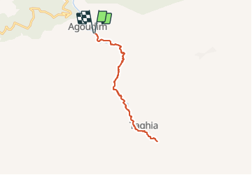
Trail Walking of 17.3 km to be discovered at Béni Mellal-Khénifra, cercle d'Azilal, Zaouiat Ahansal. This trail is proposed by annefrance70.

Description

marche sur le sentier le long de la rivière oued ahansal (aller-retour)

Elevation profile

Positioning

Country:
Morocco
Region :
Béni Mellal-Khénifra
Department/Province :
cercle d'Azilal
Municipality :
Zaouiat Ahansal
Location:
Unknown
Start:(UTM)
774611 ; 3525116 (29R) N.

Comments

Please log in to post a review or rate the element


rando super sympa, avec possibilité de louer une mule pour portage des enfants ou de matériel.


Trails nearby

Trail Walking M'Semrir - Oussikis, Maroc, avril 2017 - Photo
Walking
annefrance70

Walking

Medium
M'Semrir, Drâa-Tafilalet, cercle de Boulmane-Dadès, Morocco
7.4 km | 12 km-effort
2h 37min
Yes
Trail Walking Tabant - Ait Bouguemez. Touda - Photo
Walking
JROYER

Walking

Medium
Tabant, Béni Mellal-Khénifra, cercle d'Azilal, Morocco
7.4 km | 11.5 km-effort
2h 41min
No


Close
My subscriptions