Trail Walking Uvernet-Fours - Le Cimet. - Photo
© OpenStreetMap contributors
Length
Length
14.3 km
Max alt
Max alt
3007 m
Uphill gradient
Uphill gradient
1141 m
Km-Effort
Km-Effort  
30 km
Min alt
Min alt
2033 m
Downhill gradient
Downhill gradient
1151 m
Boucle
Boucle
Yes
Creation date :
2017-05-28 00:00:00.0
Updated on :
2019-04-29 09:17:29.824

(0 Reviews)

Walking
Walking
5h56
Difficulty : Difficult

Scan this QR Code to open this trail in the SityTrail application

FREE GPS app for hiking

Logo SityTrail SityTrail

IGN / Geographical institutes

Download SityTrail from the App Store Download SityTrail from Google Play

Logo SityTrail SityTrail World

The world is yours!

Download SityTrail from the App Store Download SityTrail from Google Play Download SityTrail on Huawei AppGallery

About

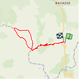
Trail Walking of 14.3 km to be discovered at Provence-Alpes-Côte d'Azur, Alpes-de-Haute-Provence, Uvernet-Fours. This trail is proposed by Dervalmarc.

Description

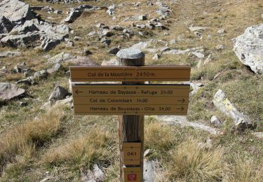
Le Cimet ou Cemet est un sommet des Alpes-de-Haute-Provence. Dans la nuit du 1?? au 2 septembre 1953, un Lockheed Constellation d'Air France venant de l'aéroport de Paris-Orly et à destination de Saïgon s'écrase contre le sommet du Cime.Le Cimet n'a rien à envier à son Voisin du Mont Pelat qui ne le dépasse que de 30 m .Randonnée dans le parc du Mercantour (chamois). Le sommet, un « 3000 » accessible, offre de beaux points de vue…

Elevation profile

Positioning

Country:
France
Region :
Provence-Alpes-Côte d'Azur
Department/Province :
Alpes-de-Haute-Provence
Municipality :
Uvernet-Fours
Location:
Unknown
Start:(UTM)
320077 ; 4905464 (32T) N.

Trails nearby

Trail Walking Uvernet-Fours - Mercantour Le Cimet 3020 m - Photo
Walking
pascalspr

Walking

Medium
(2)
Uvernet-Fours, Provence-Alpes-Côte d'Azur, Alpes-de-Haute-Provence, France
20 km | 34 km-effort
5h 49min
Yes
Trail Walking Uvernet-Fours - Mont Pelat par la grande barre - Photo
Walking
Gouze13

Walking

Difficult
(1)
Uvernet-Fours, Provence-Alpes-Côte d'Azur, Alpes-de-Haute-Provence, France
16.4 km | 34 km-effort
4h 0min
Yes
Trail Walking Uvernet-Fours - Autour de la Pierre Eclatée - Photo
Walking
tracegps

Walking

Very difficult
(1)
Uvernet-Fours, Provence-Alpes-Côte d'Azur, Alpes-de-Haute-Provence, France
13.9 km | 24 km-effort
6h 0min
Yes
Trail On foot Entraunes - Circuit des Lacs - Photo
On foot
PRO

On foot

Easy
Entraunes, Provence-Alpes-Côte d'Azur, Maritime Alps, France
8.9 km | 14.7 km-effort
3h 21min
Yes
Trail On foot Entraunes - Col de la Boucharde - Photo
On foot
PRO

On foot

Medium
Entraunes, Provence-Alpes-Côte d'Azur, Maritime Alps, France
16.6 km | 29 km-effort
6h 33min
Yes
Trail On foot Entraunes - Tête de la Boulière - Photo
On foot
PRO

On foot

Medium
Entraunes, Provence-Alpes-Côte d'Azur, Maritime Alps, France
16.9 km | 29 km-effort
6h 41min
Yes
Trail On foot Uvernet-Fours - Pointe de Colombart - Photo
On foot
PRO

On foot

Easy
Uvernet-Fours, Provence-Alpes-Côte d'Azur, Alpes-de-Haute-Provence, France
8.1 km | 11.7 km-effort
2h 40min
Yes
Trail Walking Allos - le mont Pelat et le lac du trou de l'aigle - Photo
Walking
GUIDE
amiral13

Walking

Medium
Allos, Provence-Alpes-Côte d'Azur, Alpes-de-Haute-Provence, France
14.4 km | 27 km-effort
7h 19min
Yes
Trail Walking Uvernet-Fours - LES LACS DE LA CAYOLLE - Photo
Walking
walrou63

Walking

Difficult
Uvernet-Fours, Provence-Alpes-Côte d'Azur, Alpes-de-Haute-Provence, France
9.9 km | 16 km-effort
3h 5min
Yes


Close
My subscriptions