Trail Equestrian Saint-Christophe-et-le-Laris - CAVAL07-3-ER2017  - Photo
© OpenStreetMap contributors
Length
Length
31 km
Max alt
Max alt
499 m
Uphill gradient
Uphill gradient
456 m
Km-Effort
Km-Effort  
37 km
Min alt
Min alt
298 m
Downhill gradient
Downhill gradient
572 m
Boucle
Boucle
No
Creation date :
2017-07-02 00:00:00.0
Updated on :
2017-07-02 00:00:00.0

(0 Reviews)

Equestrian
Equestrian
6h00
Difficulty : Easy

Scan this QR Code to open this trail in the SityTrail application

FREE GPS app for hiking

Logo SityTrail SityTrail

IGN / Geographical institutes

Download SityTrail from the App Store Download SityTrail from Google Play

Logo SityTrail SityTrail World

The world is yours!

Download SityTrail from the App Store Download SityTrail from Google Play Download SityTrail on Huawei AppGallery

About

Trail Equestrian of 31 km to be discovered at Auvergne-Rhône-Alpes, Drôme, Saint-Christophe-et-le-Laris. This trail is proposed by jacquesdunogier.

Description

3° étape d'un voyage de 8 jours entre Glun(07) et Bourg en Bresse(01)EQUIRANDO 2017 par l'équipe de Caval'07

Elevation profile

Positioning

Country:
France
Region :
Auvergne-Rhône-Alpes
Department/Province :
Drôme
Municipality :
Saint-Christophe-et-le-Laris
Location:
Unknown
Start:(UTM)
661098 ; 5010285 (31T) N.

Trails nearby

Trail Walking Hauterives - boucle idéale - Photo
Walking
bob2023

Walking

Easy
(1)
Hauterives, Auvergne-Rhône-Alpes, Drôme, France
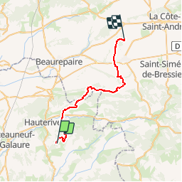
7.9 km | 9.1 km-effort
2h 29min
Yes
Trail Walking Hauterives - Hauterives amicale  - Photo
Walking
alinetpierre

Walking

Easy
Hauterives, Auvergne-Rhône-Alpes, Drôme, France
13.1 km | 17.2 km-effort
3h 4min
Yes
Trail Walking Hauterives - Hauterives  - Photo
Walking
meillon

Walking

Easy
Hauterives, Auvergne-Rhône-Alpes, Drôme, France
10.5 km | 13.2 km-effort
3h 3min
Yes
Trail Walking Montchenu - montchenu poulet 13 km  - Photo
Walking
betty26

Walking

Very easy
(1)
Montchenu, Auvergne-Rhône-Alpes, Drôme, France
12 km | 15.1 km-effort
3h 22min
Yes
Trail Walking Valherbasse - 26 château Langon  - Photo
Walking
himba26100

Walking

Easy
Valherbasse, Auvergne-Rhône-Alpes, Drôme, France
8.3 km | 11.2 km-effort
3h 13min
Yes
Trail Walking Hauterives - 26 hauterives 01.05.23 - Photo
Walking
himba26100

Walking

Easy
Hauterives, Auvergne-Rhône-Alpes, Drôme, France
15.2 km | 19.4 km-effort
4h 10min
Yes
Trail Walking Montchenu - 26 chapelle st Roche montchenu - Photo
Walking
himba26100

Walking

Easy
Montchenu, Auvergne-Rhône-Alpes, Drôme, France
12.6 km | 17.3 km-effort
3h 18min
No
Trail Bicycle tourism Hauterives - Hauterive - Crest - Photo
Bicycle tourism
karawatsj

Bicycle tourism

Medium
Hauterives, Auvergne-Rhône-Alpes, Drôme, France
78 km | 90 km-effort
4h 23min
No
Trail Walking Hauterives - reco rando facteur CHEVAL/Hauterives  - Photo
Walking
okfred26

Walking

Difficult
Hauterives, Auvergne-Rhône-Alpes, Drôme, France
14.4 km | 18.3 km-effort
4h 9min
Yes


Close
My subscriptions