Trail Walking Montalet-le-Bois - Les bonnes joies - Photo
 Fky78
Fky78

User

© OpenStreetMap contributors
Length
Length
7.1 km
Max alt
Max alt
181 m
Uphill gradient
Uphill gradient
134 m
Km-Effort
Km-Effort  
8.9 km
Min alt
Min alt
85 m
Downhill gradient
Downhill gradient
132 m
Boucle
Boucle
Yes
Creation date :
2018-04-16 21:22:39.265
Updated on :
2018-04-16 21:22:39.265

(0 Reviews)

Walking
Walking
1h59
Difficulty : Easy

Scan this QR Code to open this trail in the SityTrail application

FREE GPS app for hiking

Logo SityTrail SityTrail

IGN / Geographical institutes

Download SityTrail from the App Store Download SityTrail from Google Play

Logo SityTrail SityTrail World

The world is yours!

Download SityTrail from the App Store Download SityTrail from Google Play Download SityTrail on Huawei AppGallery

About

Trail Walking of 7.1 km to be discovered at Ile-de-France, Yvelines, Montalet-le-Bois. This trail is proposed by Fky78.

Elevation profile

Photos

Positioning

Country:
France
Region :
Ile-de-France
Department/Province :
Yvelines
Municipality :
Montalet-le-Bois
Location:
Unknown
Start:(UTM)
414577 ; 5433978 (31U) N.

Trails nearby

Trail Walking Brueil-en-Vexin - Breuil en Vexin - Photo
Walking
fredouille661

Walking

Easy
(1)
Brueil-en-Vexin, Ile-de-France, Yvelines, France
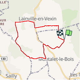
11.5 km | 13.5 km-effort
2h 10min
Yes
Trail Nordic walking Frémainville - Forêt de Galluis - Photo
Nordic walking
Fky78

Nordic walking

Easy
(1)
Frémainville, Ile-de-France, Val-d'Oise, France
6 km | 7.3 km-effort
1h 20min
Yes
Trail Walking Arthies - Petite Randonnée des Cinq châteaux - Arthies - Photo
Walking
tracegps

Walking

Medium
(2)
Arthies, Ile-de-France, Val-d'Oise, France
14 km | 17.3 km-effort
3h 0min
Yes
Trail Walking Frémainville - Fremainville marche 6km - Photo
Walking
unirega

Walking

Medium
(2)
Frémainville, Ile-de-France, Val-d'Oise, France
5.8 km | 7.9 km-effort
1h 20min
No
Trail Walking Seraincourt - la cave aux fées  - Photo
Walking
laurentbernardbrunel

Walking

Easy
(2)
Seraincourt, Ile-de-France, Val-d'Oise, France
13 km | 16.1 km-effort
2h 35min
Yes
Trail Walking Oinville-sur-Montcient - Oinville sur Moncient - Photo
Walking
fredouille661

Walking

Very easy
(1)
Oinville-sur-Montcient, Ile-de-France, Yvelines, France
10.9 km | 13.8 km-effort
2h 39min
Yes
Trail Walking Théméricourt - Théméricourt - La vallée de l''Aubette - Photo
Walking
marcel.F

Walking

Easy
(1)
Théméricourt, Ile-de-France, Val-d'Oise, France
10.4 km | 12.3 km-effort
2h 42min
Yes
Trail Walking Gaillon-sur-Montcient - En passant par Dalibray - Photo
Walking
Fky78

Walking

Difficult
Gaillon-sur-Montcient, Ile-de-France, Yvelines, France
10.1 km | 12.8 km-effort
2h 34min
Yes
Trail On foot Oinville-sur-Montcient - GR2 Accès - Photo
On foot
PRO

On foot

Easy
Oinville-sur-Montcient, Ile-de-France, Yvelines, France
4.3 km | 4.9 km-effort
1h 6min
No


Close
My subscriptions