Trail Walking Glandage - BORNE-ARETES DE JIBOUI et COL-SUCETTES DE BORNE-23-08-2017 - Photo

BORNE-ARETES DE JIBOUI et COL-SUCETTES DE BORNE-23-08-2017

 RD78-38
RD78-38

User

© OpenStreetMap contributors
Length
Length
17.5 km
Max alt
Max alt
1760 m
Uphill gradient
Uphill gradient
970 m
Km-Effort
Km-Effort  
30 km
Min alt
Min alt
926 m
Downhill gradient
Downhill gradient
975 m
Boucle
Boucle
Yes
Creation date :
2018-04-16 22:13:19.923
Updated on :
2020-07-11 00:21:29.174

(0 Reviews)

Walking
Walking
7h26
Difficulty : Easy

Scan this QR Code to open this trail in the SityTrail application

FREE GPS app for hiking

Logo SityTrail SityTrail

IGN / Geographical institutes

Download SityTrail from the App Store Download SityTrail from Google Play

Logo SityTrail SityTrail World

The world is yours!

Download SityTrail from the App Store Download SityTrail from Google Play Download SityTrail on Huawei AppGallery

About

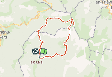
Trail Walking of 17.5 km to be discovered at Auvergne-Rhône-Alpes, Drôme, Glandage. This trail is proposed by RD78-38.

Description

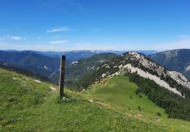
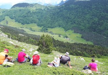
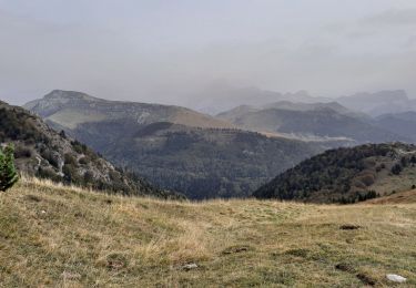
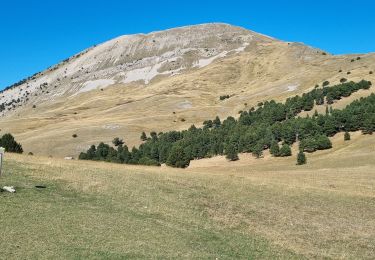
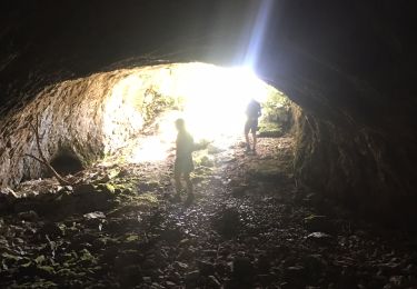
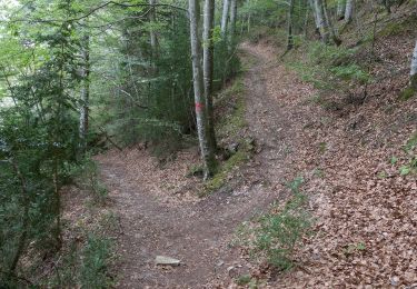
Très bonne Randonnée au départ du parking des sucettes de Borne. Les "Must" du circuit : les crêtes du JIBOUI et les SUCETTES de BORNE. Parcours souvent en beaux sous-bois longés par ruisseau et cascades donnant de la fraîcheur par temps chaud au soleil. Superbe vue panoramique depuis les crêtes du Jiboui. Voir photos pour avoir une idée des paysages rencontrés. Circuit assez facile avec 2 ou 3 petits raidillons. À faire.

Elevation profile

Photos

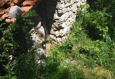
39 photos in total. Please click on a photo to see them all in the gallery.

Positioning

Country:
France
Region :
Auvergne-Rhône-Alpes
Department/Province :
Drôme
Municipality :
Glandage
Location:
Unknown
Start:(UTM)
705226 ; 4954868 (31T) N.

Comments

Please log in to post a review or rate the element


Trails nearby

Trail Walking Châtillon-en-Diois - F26 Combau Fontaine Pourrie - Photo
Walking
ageo

Walking

Medium
(1)
Châtillon-en-Diois, Auvergne-Rhône-Alpes, Drôme, France
17 km | 29 km-effort
6h 9min
Yes
Trail Walking Glandage - Grimone-Le Jocou 12km - Photo
Walking
GUIDE
thonyc

Walking

Difficult
Glandage, Auvergne-Rhône-Alpes, Drôme, France
12 km | 24 km-effort
6h 0min
Yes
Trail Walking Châtillon-en-Diois - 2017-06-04 15:45:22 - Photo
Walking
randochu

Walking

Medium
(1)
Châtillon-en-Diois, Auvergne-Rhône-Alpes, Drôme, France
11.4 km | 19.9 km-effort
Unknown
Yes
Trail Walking Châtillon-en-Diois - La boucle du Mont Barral - Photo
Walking
GUIDE
R@ph

Walking

Difficult
Châtillon-en-Diois, Auvergne-Rhône-Alpes, Drôme, France
7.5 km | 14.9 km-effort
3h 7min
Yes
Trail Walking Glandage - Le Jocou 2 - Photo
Walking
Marco05

Walking

Difficult
Glandage, Auvergne-Rhône-Alpes, Drôme, France
8.5 km | 18.1 km-effort
4h 0min
Yes
Trail Walking Châtillon-en-Diois - mont barral - Photo
Walking
scalpy

Walking

Difficult
Châtillon-en-Diois, Auvergne-Rhône-Alpes, Drôme, France
7.7 km | 15 km-effort
4h 8min
Yes
Trail Walking Châtillon-en-Diois - Pellebit - Photo
Walking
ajd26

Walking

Very difficult
Châtillon-en-Diois, Auvergne-Rhône-Alpes, Drôme, France
14.2 km | 27 km-effort
6h 13min
Yes
Trail Walking Châtillon-en-Diois - Circuit des Baumes - Pont de vachères-Soubreroche - Boulc - Photo
Walking
Philindy26

Walking

Medium
Châtillon-en-Diois, Auvergne-Rhône-Alpes, Drôme, France
11.4 km | 18.5 km-effort
4h 20min
Yes
Trail Walking Châtillon-en-Diois - 26 vallon combeau - Photo
Walking
himba26100

Walking

Medium
Châtillon-en-Diois, Auvergne-Rhône-Alpes, Drôme, France
13.3 km | 24 km-effort
6h 48min
Yes


Close
My subscriptions