Trail Walking Gattières - Via Aurelia La Manda- Vence - Photo
© OpenStreetMap contributors
Length
Length
21 km
Max alt
Max alt
409 m
Uphill gradient
Uphill gradient
759 m
Km-Effort
Km-Effort  
30 km
Min alt
Min alt
63 m
Downhill gradient
Downhill gradient
501 m
Boucle
Boucle
No
Creation date :
2018-04-17 14:23:40.228
Updated on :
2018-04-17 14:23:40.228

(0 Reviews)

Walking
Walking
6h36
Difficulty : Medium

Scan this QR Code to open this trail in the SityTrail application

FREE GPS app for hiking

Logo SityTrail SityTrail

IGN / Geographical institutes

Download SityTrail from the App Store Download SityTrail from Google Play

Logo SityTrail SityTrail World

The world is yours!

Download SityTrail from the App Store Download SityTrail from Google Play Download SityTrail on Huawei AppGallery

About

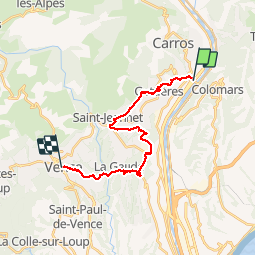
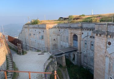
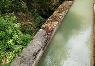
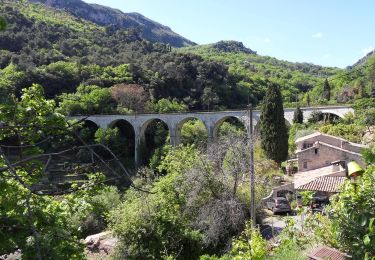
Trail Walking of 21 km to be discovered at Provence-Alpes-Côte d'Azur, Maritime Alps, Gattières. This trail is proposed by PEBREJOSIANE.

Description

rando facile qui suit en gros les GR 653 et 51
Aller train des Pignes arrêt La Manda
retour bus 300 départ toutes les 1/2 h de Vence
750m de D  et 20km de longueur

Elevation profile

Positioning

Country:
France
Region :
Provence-Alpes-Côte d'Azur
Department/Province :
Maritime Alps
Municipality :
Gattières
Location:
Unknown
Start:(UTM)
355269 ; 4847427 (32T) N.

Trails nearby

Trail Walking Saint-Jeannet - Baou de Saint-Jeannet - Photo
Walking
Jean-François Thibaud

Walking

Medium
(1)
Saint-Jeannet, Provence-Alpes-Côte d'Azur, Maritime Alps, France
7.5 km | 13.4 km-effort
3h 15min
No
Trail Walking Aspremont - Aspremont tour du Mont Chauve, montée au fort. - Photo
Walking
jll7513

Walking

Difficult
(1)
Aspremont, Provence-Alpes-Côte d'Azur, Maritime Alps, France
7.5 km | 12 km-effort
2h 44min
Yes
Trail Walking Aspremont - Vallon OBSCUR aux portes de Nice  - Photo
Walking
clarambre

Walking

Medium
(1)
Aspremont, Provence-Alpes-Côte d'Azur, Maritime Alps, France
5.4 km | 8.5 km-effort
3h 20min
Yes
Trail On foot Gattières - Baou de la Gaude - Photo
On foot
PRO

On foot

Easy
Gattières, Provence-Alpes-Côte d'Azur, Maritime Alps, France
9.5 km | 17.7 km-effort
4h 1min
Yes
Trail On foot Carros - Les Balcons de Carros - Photo
On foot
PRO

On foot

Easy
Carros, Provence-Alpes-Côte d'Azur, Maritime Alps, France
4.9 km | 9.1 km-effort
2h 4min
Yes
Trail On foot Saint-Jeannet - Circuit du Castellet - Photo
On foot
PRO

On foot

Easy
Saint-Jeannet, Provence-Alpes-Côte d'Azur, Maritime Alps, France
8.2 km | 14.1 km-effort
3h 12min
Yes
Trail Walking Le Broc - mouton d'anou depuis le broc - Photo
Walking
Michel06

Walking

Easy
(1)
Le Broc, Provence-Alpes-Côte d'Azur, Maritime Alps, France
14.3 km | 23 km-effort
5h 13min
Yes
Trail Running Aspremont - Tour des Monts d'Aspremont 2007 - Photo
Running
tracegps

Running

Very difficult
(2)
Aspremont, Provence-Alpes-Côte d'Azur, Maritime Alps, France
21 km | 33 km-effort
3h 0min
Yes
Trail Walking Saint-Jeannet - Baous de la Gaude et de St Jeannet - Photo
Walking
GrouGary

Walking

Medium
Saint-Jeannet, Provence-Alpes-Côte d'Azur, Maritime Alps, France
15 km | 26 km-effort
5h 51min
Yes


Close
My subscriptions