Trail Walking Saint-Julien-de-Concelles - Saint-Julien-de-Concelle - Entre Loire et Maraîchages - Photo

Saint-Julien-de-Concelle - Entre Loire et Maraîchages

 TEFFRA
TEFFRA

User

© OpenStreetMap contributors
Length
Length
10 km
Max alt
Max alt
10 m
Uphill gradient
Uphill gradient
50 m
Km-Effort
Km-Effort  
10.7 km
Min alt
Min alt
0 m
Downhill gradient
Downhill gradient
50 m
Boucle
Boucle
Yes
Creation date :
2018-04-17 14:42:38.364
Updated on :
2018-04-17 14:42:38.364

(0 Reviews)

Walking
Walking
2h22
Difficulty : Easy

Scan this QR Code to open this trail in the SityTrail application

FREE GPS app for hiking

Logo SityTrail SityTrail

IGN / Geographical institutes

Download SityTrail from the App Store Download SityTrail from Google Play

Logo SityTrail SityTrail World

The world is yours!

Download SityTrail from the App Store Download SityTrail from Google Play Download SityTrail on Huawei AppGallery

About

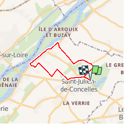
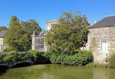
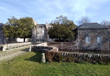
Trail Walking of 10 km to be discovered at Pays de la Loire, Loire-Atlantique, Saint-Julien-de-Concelles. This trail is proposed by TEFFRA.

Description

Point de RDV parking du plan d'eau du Chêne

Elevation profile

Positioning

Country:
France
Region :
Pays de la Loire
Department/Province :
Loire-Atlantique
Municipality :
Saint-Julien-de-Concelles
Location:
Unknown
Start:(UTM)
622736 ; 5234668 (30T) N.

Trails nearby

Trail Mountain bike Thouaré-sur-Loire - Thouaré sur loire-Tharon via Mindin - Photo
Mountain bike
boboss4x4

Mountain bike

Medium
(5)
Thouaré-sur-Loire, Pays de la Loire, Loire-Atlantique, France
82 km | 89 km-effort
4h 12min
No
Trail On foot Divatte-sur-Loire - La Haute Chapelle - Photo
On foot
PRO

On foot

Easy
Divatte-sur-Loire, Pays de la Loire, Loire-Atlantique, France
10.5 km | 12.4 km-effort
2h 48min
No
Trail On foot Divatte-sur-Loire - La Haute Chapelle (variante) - Photo
On foot
PRO

On foot

Easy
Divatte-sur-Loire, Pays de la Loire, Loire-Atlantique, France
9.3 km | 10.7 km-effort
2h 26min
No
Trail Walking Divatte-sur-Loire - La Chapelle-Basse-Mer - nord-ouest - Photo
Walking
TEFFRA

Walking

Easy
(1)
Divatte-sur-Loire, Pays de la Loire, Loire-Atlantique, France
9.1 km | 9.6 km-effort
2h 8min
Yes
Trail Walking Le Loroux-Bottereau - Loroux au pont de l’ouzbek - Photo
Walking
PhilippeLegault

Walking

Le Loroux-Bottereau, Pays de la Loire, Loire-Atlantique, France
12.3 km | 14.1 km-effort
3h 27min
Yes
Trail Walking Divatte-sur-Loire - Circuit de la haute chapelle  - Photo
Walking
PhilippeLegault

Walking

Divatte-sur-Loire, Pays de la Loire, Loire-Atlantique, France
11.8 km | 13.7 km-effort
3h 7min
Yes
Trail Road bike Divatte-sur-Loire - TLA Circuit Arrivée Etape 2 - Photo
Road bike
milk44

Road bike

Medium
Divatte-sur-Loire, Pays de la Loire, Loire-Atlantique, France
6.4 km | 7.5 km-effort
10min
Yes
Trail Walking Le Loroux-Bottereau - rando du vignoble avec liaison - Photo
Walking
Benaissa Laidi

Walking

Easy
Le Loroux-Bottereau, Pays de la Loire, Loire-Atlantique, France
21 km | 24 km-effort
3h 43min
No
Trail Walking Mauves-sur-Loire - Mauves mon rêve de loire  - Photo
Walking
TonioNantes

Walking

Difficult
Mauves-sur-Loire, Pays de la Loire, Loire-Atlantique, France
50 km | 61 km-effort
10h 37min
Yes


Close
My subscriptions