Trail Snowshoes Grust - Tuc des Arribans - Photo
© OpenStreetMap contributors
Length
Length
7.2 km
Max alt
Max alt
2081 m
Uphill gradient
Uphill gradient
430 m
Km-Effort
Km-Effort  
12.9 km
Min alt
Min alt
1679 m
Downhill gradient
Downhill gradient
431 m
Boucle
Boucle
Yes
Creation date :
2018-04-17 15:12:52.555
Updated on :
2018-04-17 15:12:52.555

(0 Reviews)

Snowshoes
Snowshoes
4h14
Difficulty : Medium

Scan this QR Code to open this trail in the SityTrail application

FREE GPS app for hiking

Logo SityTrail SityTrail

IGN / Geographical institutes

Download SityTrail from the App Store Download SityTrail from Google Play

Logo SityTrail SityTrail World

The world is yours!

Download SityTrail from the App Store Download SityTrail from Google Play Download SityTrail on Huawei AppGallery

About

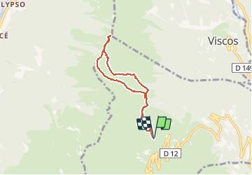
Trail Snowshoes of 7.2 km to be discovered at Occitania, Hautespyrenees, Grust. This trail is proposed by fredopaca.

Description

départ sation luz ardiden parking bederet  vers cabane de counques prend avant vers les crêtes tuc des Arribans vers le pic de viscos

Elevation profile

Positioning

Country:
France
Region :
Occitania
Department/Province :
Hautespyrenees
Municipality :
Grust
Location:
Unknown
Start:(UTM)
740064 ; 4753090 (30T) N.

Trails nearby

Trail Walking Cauterets - Lac d'Estom - Photo
Walking
Philindy26

Walking

Medium
(1)
Cauterets, Occitania, Hautespyrenees, France
11.4 km | 17.5 km-effort
3h 30min
Yes
Trail Walking Sazos - Lac de Lagües - Photo
Walking
DuMarsan

Walking

Medium
(2)
Sazos, Occitania, Hautespyrenees, France
9.1 km | 18.9 km-effort
5h 14min
Yes
Trail Walking Cauterets - contrefort de Cauterets - Photo
Walking
christian33

Walking

Medium
(1)
Cauterets, Occitania, Hautespyrenees, France
13.7 km | 21 km-effort
4h 21min
Yes
Trail Walking Grust - PIC DE VISCOS - Photo
Walking
PVERTICAL

Walking

Medium
(1)
Grust, Occitania, Hautespyrenees, France
10.5 km | 18.4 km-effort
4h 7min
Yes
Trail Walking Cauterets - promenade Russell - Photo
Walking
pffrench

Walking

Very easy
(1)
Cauterets, Occitania, Hautespyrenees, France
11.9 km | 21 km-effort
5h 46min
Yes
Trail Walking Cauterets - Chemin des cascades - Photo
Walking
herve.feurprier

Walking

Easy
(1)
Cauterets, Occitania, Hautespyrenees, France
8 km | 12.6 km-effort
2h 30min
No
Trail Walking Sazos - Lac de Bastampe 2019m - Photo
Walking
tracegps

Walking

Difficult
(1)
Sazos, Occitania, Hautespyrenees, France
13 km | 27 km-effort
5h 0min
Yes
Trail Walking Cauterets - CAUTERETS Le chemin des pères G3 le 14/10/2022
Walking
GUIDE
marmotte65

Walking

Medium
Cauterets, Occitania, Hautespyrenees, France
9.4 km | 15.3 km-effort
3h 5min
Yes
Trail On foot Luz-Saint-Sauveur - LUZ SAINT SAUVEUR Les chemins de l agnouede bis - Photo
On foot
GUIDE
marmotte65

On foot

Easy
Luz-Saint-Sauveur, Occitania, Hautespyrenees, France
11.8 km | 18.5 km-effort
4h 12min
Yes


Close
My subscriptions