Trail Nordic walking Loubeyrat - Le Bouquet - Le roc du diable - Photo

Le Bouquet - Le roc du diable

 Gegetop
Gegetop

User

© OpenStreetMap contributors
Length
Length
11 km
Max alt
Max alt
658 m
Uphill gradient
Uphill gradient
317 m
Km-Effort
Km-Effort  
15.2 km
Min alt
Min alt
427 m
Downhill gradient
Downhill gradient
316 m
Boucle
Boucle
Yes
Creation date :
2018-06-26 13:07:29.525
Updated on :
2018-06-26 13:07:29.525

(0 Reviews)

Nordic walking
Nordic walking
2h46
Difficulty : Medium

Scan this QR Code to open this trail in the SityTrail application

FREE GPS app for hiking

Logo SityTrail SityTrail

IGN / Geographical institutes

Download SityTrail from the App Store Download SityTrail from Google Play

Logo SityTrail SityTrail World

The world is yours!

Download SityTrail from the App Store Download SityTrail from Google Play Download SityTrail on Huawei AppGallery

About

Trail Nordic walking of 11 km to be discovered at Auvergne-Rhône-Alpes, Puy-de-Dôme, Loubeyrat. This trail is proposed by Gegetop.

Description

Boucle avec fort dénivelé.

Elevation profile

Photos

Points of interest

Point of interest Prompsat - Point 1 Ruisseau - Photo
Gegetop
Point of interest Prompsat - Point 3 Roc du diable - Photo
Gegetop
Point of interest Prompsat - Point 4 Prompsat  - Photo
Gegetop

Positioning

Country:
France
Region :
Auvergne-Rhône-Alpes
Department/Province :
Puy-de-Dôme
Municipality :
Loubeyrat
Location:
Unknown
Start:(UTM)
502771 ; 5087249 (31T) N.

Trails nearby

Trail On foot Loubeyrat - La Vallee des Prades - Photo
On foot
PRO

On foot

Easy
(1)
Loubeyrat, Auvergne-Rhône-Alpes, Puy-de-Dôme, France
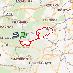
11.1 km | 15.6 km-effort
3h 33min
Yes
Trail Walking Enval - Enval_Gorges - Photo
Walking
GUIDE
jagarnier

Walking

Medium
(1)
Enval, Auvergne-Rhône-Alpes, Puy-de-Dôme, France
9.1 km | 13.2 km-effort
2h 45min
Yes
Trail Walking Loubeyrat - Le roc du diable - Prompsat - Photo
Walking
Gegetop

Walking

Medium
(1)
Loubeyrat, Auvergne-Rhône-Alpes, Puy-de-Dôme, France
9.5 km | 13.4 km-effort
2h 20min
Yes
Trail Walking Teilhède - Teilhede - Photo
Walking
Gegetop

Walking

Easy
(1)
Teilhède, Auvergne-Rhône-Alpes, Puy-de-Dôme, France
6.5 km | 8.7 km-effort
1h 38min
Yes
Trail Walking Gimeaux - Chemin de Fontête - Photo
Walking
Gegetop

Walking

Easy
(2)
Gimeaux, Auvergne-Rhône-Alpes, Puy-de-Dôme, France
8.6 km | 11.9 km-effort
2h 6min
Yes
Trail Walking Châtel-Guyon - Les Briffons-Bois d'Agnat - Photo
Walking
Gegetop

Walking

Easy
(2)
Châtel-Guyon, Auvergne-Rhône-Alpes, Puy-de-Dôme, France
10.6 km | 14.8 km-effort
3h 14min
Yes
Trail Walking Châtel-Guyon - Chazeron sans souci - Photo
Walking
Gegetop

Walking

Easy
(1)
Châtel-Guyon, Auvergne-Rhône-Alpes, Puy-de-Dôme, France
6.6 km | 9.7 km-effort
1h 45min
Yes
Trail Walking Châtel-Guyon - Boucle de Rochepradière en passant par Douhady - Photo
Walking
Gegetop

Walking

Easy
(1)
Châtel-Guyon, Auvergne-Rhône-Alpes, Puy-de-Dôme, France
6.7 km | 9.7 km-effort
2h 6min
Yes
Trail Walking Châtel-Guyon - Le tour de Montaclier - Saint Hippolyte - Photo
Walking
tracegps

Walking

Difficult
(1)
Châtel-Guyon, Auvergne-Rhône-Alpes, Puy-de-Dôme, France
14 km | 19.6 km-effort
3h 30min
Yes


Close
My subscriptions