Trail Motor L'Étoile - Hivernale04-12-2011 - Photo

Hivernale04-12-2011

 sd0001
sd0001

User

© OpenStreetMap contributors
Length
Length
113 km
Max alt
Max alt
177 m
Uphill gradient
Uphill gradient
1317 m
Km-Effort
Km-Effort  
131 km
Min alt
Min alt
37 m
Downhill gradient
Downhill gradient
1377 m
Boucle
Boucle
No
Creation date :
2014-12-10 00:00:00.0
Updated on :
2014-12-10 00:00:00.0

(0 Reviews)

Motor
Motor
5h55
Difficulty : Difficult

Scan this QR Code to open this trail in the SityTrail application

FREE GPS app for hiking

Logo SityTrail SityTrail

IGN / Geographical institutes

Download SityTrail from the App Store Download SityTrail from Google Play

Logo SityTrail SityTrail World

The world is yours!

Download SityTrail from the App Store Download SityTrail from Google Play Download SityTrail on Huawei AppGallery

About

Trail Motor of 113 km to be discovered at Hauts-de-France, Somme, L'Étoile. This trail is proposed by sd0001.

Elevation profile

Points of interest

Point of interest Beauval - Antenne Téléphone - Photo
sd0001
Point of interest Lucheux - Bourbier - Photo
sd0001
LUCHEUX 
Point of interest Lucheux - Bourbier - Photo
sd0001
LUCHEUX 

Positioning

Country:
France
Region :
Hauts-de-France
Department/Province :
Somme
Municipality :
L'Étoile
Location:
Unknown
Start:(UTM)
432852 ; 5543040 (31U) N.

Trails nearby

Trail Walking Ville-le-Marclet - ville le marclet - Photo
Walking
Cheyenne80

Walking

Very easy
Ville-le-Marclet, Hauts-de-France, Somme, France
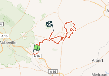
10 km | 11.5 km-effort
2h 32min
Yes
Trail On foot Condé-Folie - Les Marais de Condé-Folie - Photo
On foot
PRO

On foot

Easy
Condé-Folie, Hauts-de-France, Somme, France
5.4 km | 5.7 km-effort
1h 18min
Yes
Trail Walking Condé-Folie - Condé-Folie  - Photo
Walking
jpblimond

Walking

Medium
Condé-Folie, Hauts-de-France, Somme, France
17.2 km | 20 km-effort
3h 54min
Yes
Trail Cycle Domart-en-Ponthieu - Les Muches - Domart en Ponthieu - Photo
Cycle
tracegps

Cycle

Difficult
Domart-en-Ponthieu, Hauts-de-France, Somme, France
60 km | 69 km-effort
3h 0min
Yes
Trail Walking Bouchon - Les larris de la vallée de Bouchon à Villers-sous-Ailly - Photo
Walking
tracegps

Walking

Very difficult
Bouchon, Hauts-de-France, Somme, France
12.5 km | 15.1 km-effort
3h 10min
Yes
Trail On foot Villers-sous-Ailly - Les Larris de Bouchon et Villers - Photo
On foot
PRO

On foot

Easy
Villers-sous-Ailly, Hauts-de-France, Somme, France
3.1 km | 3.8 km-effort
52min
No
Trail Electric bike Longpré-les-Corps-Saints - LONGPRE OISEMONT - Photo
Electric bike
ORTAX

Electric bike

Very easy
Longpré-les-Corps-Saints, Hauts-de-France, Somme, France
38 km | 42 km-effort
2h 30min
Yes
Trail Walking Condé-Folie - Affût  - Photo
Walking
manu_gps

Walking

Easy
Condé-Folie, Hauts-de-France, Somme, France
1.7 km | 1.8 km-effort
21min
No


Close
My subscriptions