Trail Electric bike Échavanne - VTTAE- malsaucy-Salbert-Echavanne - Photo

VTTAE- malsaucy-Salbert-Echavanne

© OpenStreetMap contributors
Length
Length
37 km
Max alt
Max alt
631 m
Uphill gradient
Uphill gradient
871 m
Km-Effort
Km-Effort  
48 km
Min alt
Min alt
347 m
Downhill gradient
Downhill gradient
871 m
Boucle
Boucle
Yes
Creation date :
2018-06-26 14:11:06.379
Updated on :
2018-12-03 09:31:29.018

(0 Reviews)

Electric bike
Electric bike
2h30
Difficulty : Medium

Scan this QR Code to open this trail in the SityTrail application

FREE GPS app for hiking

Logo SityTrail SityTrail

IGN / Geographical institutes

Download SityTrail from the App Store Download SityTrail from Google Play

Logo SityTrail SityTrail World

The world is yours!

Download SityTrail from the App Store Download SityTrail from Google Play Download SityTrail on Huawei AppGallery

About

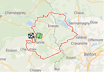
Trail Electric bike of 37 km to be discovered at Bourgogne-Franche-Comté, Haute-Saône, Échavanne. This trail is proposed by benoit747.

Description

Tour de VTTAE très sympa
Si réalisé en VTT standard, attention à la montée du salbert qui est très directe et demande une excellente condition
pas mal de single track sympa

Elevation profile

Positioning

Country:
France
Region :
Bourgogne-Franche-Comté
Department/Province :
Haute-Saône
Municipality :
Échavanne
Location:
Unknown
Start:(UTM)
329748 ; 5280720 (32T) N.

Trails nearby

Trail Walking Châlonvillars - Châlonvillars - Fort du Salbert - Evette-Salbert - Photo
Walking
Bart2015

Walking

Difficult
(1)
Châlonvillars, Bourgogne-Franche-Comté, Haute-Saône, France
11 km | 15.8 km-effort
3h 36min
Yes
Trail Mountain bike Châlonvillars - Châlonvillars - Fort Giromagny en passant au milieu des étangs - Photo
Mountain bike
Bart2015

Mountain bike

Very difficult
Châlonvillars, Bourgogne-Franche-Comté, Haute-Saône, France
40 km | 51 km-effort
3h 31min
Yes
Trail Mountain bike Châlonvillars - Châlonvillars - Menhir - Mandrevillars - Fort Essert et du Salbert - Photo
Mountain bike
Bart2015

Mountain bike

Very difficult
Châlonvillars, Bourgogne-Franche-Comté, Haute-Saône, France
31 km | 42 km-effort
2h 53min
Yes
Trail Walking Champagney - Canal souterrain de la Haute-Saône - Photo
Walking
Bart2015

Walking

Difficult
Champagney, Bourgogne-Franche-Comté, Haute-Saône, France
10.1 km | 13.4 km-effort
3h 3min
Yes
Trail Walking Châlonvillars - Châlonvillars - le mehnir - Mandrevillars - Photo
Walking
Bart2015

Walking

Medium
Châlonvillars, Bourgogne-Franche-Comté, Haute-Saône, France
13.4 km | 17.1 km-effort
2h 39min
Yes
Trail Walking Châlonvillars - Châlonvillars - Mandrevillars - Photo
Walking
Bart2015

Walking

Easy
Châlonvillars, Bourgogne-Franche-Comté, Haute-Saône, France
9.5 km | 11.9 km-effort
1h 33min
Yes
Trail Walking Frahier-et-Chatebier - frahier - Photo
Walking
Evelyne3

Walking

Medium
(1)
Frahier-et-Chatebier, Bourgogne-Franche-Comté, Haute-Saône, France
5.6 km | 6.8 km-effort
1h 44min
Yes
Trail Walking Châlonvillars - Châlonvillars - Mandrevillars par les bois - Photo
Walking
Bart2015

Walking

Easy
Châlonvillars, Bourgogne-Franche-Comté, Haute-Saône, France
10.4 km | 12.9 km-effort
1h 40min
Yes
Trail Walking Châlonvillars - Châlonvillars - les étangs - fort du Salbert - grottes Cravanche - Photo
Walking
Bart2015

Walking

Medium
Châlonvillars, Bourgogne-Franche-Comté, Haute-Saône, France
13.2 km | 20 km-effort
2h 46min
Yes


Close
My subscriptions